Ever since the earliest days of the Utah state highway system, Brigham City and Logan have been connected by a major state highway. But over the years, various alignments and route designations have changed.
Before we start actually discussing route histories, we'll do a brief geography lesson. If you ask a Utah local what the Brigham City to Logan highway passes through, there's a very good chance the answer will be "Sardine Canyon". However, while everyone does it, using the name Sardine Canyon to refer to any portion of US 89/91 is technically incorrect.
In fact, according to an
article in the Ogden Standard-Examiner, the modern highway passes through three separate canyons in the Wellsville Mountains, none of which are named Sardine. Heading east from Brigham City, it runs through Box Elder Canyon (which contains Box Elder Creek) before opening into a small valley that contains the town of Mantua. From there, it heads north through Dry Canyon to the 5900-foot Sardine Summit on the Box Elder-Cache County line. Immediately on the other side is Dry Lake, a small closed basin that, despite its name, fills up with water regularly in spring or after heavy rain events. The highway then descends Wellsville Canyon (containing Wellsville Creek) before opening out into the Cache Valley.
But as it turns out, there actually
is a Sardine Canyon, which connects Dry Lake to the Cache Valley a couple miles south of Wellsville Canyon. All four canyons are labeled on this map below.
So why do people refer to the highway as Sardine Canyon? As it turns out, Sardine Canyon was the route of the Mormon pioneers that settled in Cache Valley, and it would later be used for an alignment of US 91 up until the 1950s. But it isn't as simple as that: over the years, there have been at least four routes descending the east side of the Wellsville Mountains.
The first route, used by Mormon pioneers, descended to Dry Lake, but then turned east to Sardine Spring and followed the bottom of Sardine Canyon northwest to Hyrum, proceeding north to Logan from there. But that was more a trail than a road; when the first road was built in the 1870s, it turned east about halfway between Sardine Summit and Dry Lake. That went down a canyon marked on many maps as Baxter Hollow or McMurdie Hollow, descending to what is now Paradise. From there it went north through Hyrum to Logan.
That could have been the route of the original 1910 state highway. If that was the case, it's unclear how it would have gotten from Paradise to Hyrum to Logan - I don't know of any detailed maps from that far back. The road that is now SR 165 would be the obvious candidate, but that may not have existed at the time. There was also a road through Wellsville Canyon, which apparently had existed as far back as 1878, but was clearly secondary to the Baxter Hollow road at the time. Perhaps this road had been improved enough by 1910 to make it the preferred state highway - as far as I know, none of the pre-1919 descriptions were specific on how the highway got from Brigham City to Logan. Here is a 1914 topo map of the southwestern Cache Valley:
 |
| USGS (Logan), 1914. |
In addition to the main route through Mantua and over Sardine Summit, the state also added a route from Brigham City to Logan via Collinston in 1916. That corresponded to the modern SR 38 and part of SR 30, but it followed a slightly different alignment through the Cache Valley, and it only lasted three years anyway.
In 1919, the state legislature limited the state highway system to 20 designated corridors, plus any federal aid projects. As the Collinston road was not on any of the corridors or a federal-aid project, it was removed from the system that year. However, the route through Mantua and Sardine Summit was included in section A of the highway code, and given a more detailed description:
...to Logan, thence in a generally southwesterly direction via the Amalgamated Sugar Factory, Wellsville, Wellsville Canyon and Mantua to Brigham City...
That clarified that by 1919, the state highway was via Wellsville Canyon. A few years later, the Utah State Road Commission assigned numbers to some of the most important state highways; the Brigham City-Logan road via Mantua became part of SR 1.
The alignment of the main route over Sardine Summit would change yet again in 1924. That year, a new road opened from Dry Lake down the northern side of Sardine Canyon, entering Wellsville from the south along Center Street. Most of that is still marked on many maps as "Old Sardine Canyon Hwy" or something similar. It's shown in blue on this map:
 |
| The 1924 Sardine Canyon alignment. |
It was much easier to clear heavy snow from this new alignment when it fell during winter. After a particularly heavy storm, it apparently would take a week or two to plow the road. If that sounds like a lot to you, consider this: the old road would take months to clear and as a result was pretty much closed throughout the winter. Within a year, Cache County stationed a snow-plowing tractor at Sardine Summit permanently, solving most of the snow problems.
In 1926, the highway became US 91, and SR 1 became an unsigned legislative designation. Within the town of Wellsville, the highway used Center Street (now SR 23) and Main Street (now SR 101):
 |
| US Census, 1940. |
Meanwhile, the Brigham City-Logan route through Collinston was added back to the state system in 1931, as SR 69. It showed up on this 1937 map:
 |
| Rand McNally/Texaco (Idaho-Montana-Wyoming), 1937. |
SR 69 began at US 30S just north of Brigham City, at the intersection of what is now Main Street and Promontory Road. From there, it proceeded north through Honeyville, Deweyville, and Collinston, before turning east over Beaver Dam Summit into Cache County. The map above suggests SR 69 (and probably the pre-1919 state highway before it) originally took a route across the Cache Valley a bit north of today's SR 30 - probably entering along what's now 2000 North, then north along what's now SR 23, then east on 3000 North to Benson. After that, it probably dropped down along 3200 West, then curved east onto the modern SR 30 alignment before entering Logan.
Also notice that map shows US 89 has been extended north, and is concurrent with US 91 in this area. At the time, US 89 was officially defined to run further east - a dispute was ongoing between Utah/Idaho and Wyoming over the future route of US 89 north of Spanish Fork, Utah (where it had originally ended). The 1937 map showed both the Utah-Idaho and Wyoming proposed routes. That dispute will be detailed further in a future post.
In late 1938, the 89 alignment was finalized: Utah and Idaho wound up on the winning side of the dispute, with Wyoming's proposal instead becoming US 189. Here is a map from the next year:
 |
| Rand McNally/State Farm (Nevada-Utah), 1939. |
Also, it looks like the modern alignment across the western Cache Valley existed in full by then. But the 89-91 concurrency indicated here is most likely an error, because the 1938 description had US 89 departing 91 between Brigham City and Logan, going via Collinston instead of Mantua. In other words, it was extended over SR 69, which would have become an unsigned legislative designation at that point. The 1940 map got that right:
 |
| Rand McNally/State Farm (Nevada-Utah), 1940. |
The 69 realignment and subsequent extension of US 89 over it was done to ensure an all-weather US route to the Cache Valley was always available, due to Sardine Summit's frequent heavy snows. (This fact will probably be familiar to anyone who has spent a winter or two in northern Utah; even today US 89/91 regularly closes over Sardine Summit during strong winter storms.) Although the Collinston route was significantly less direct, it had much gentler grades and crossed the Wellsville Mountains at a pass 1000 feet lower than Sardine, so it was much easier to keep open.
Sometime during the 1940s, several realignments were made along the Brigham City-Logan road. Originally, US 91 left town to the east along 100 South:
 |
| USRC/Gousha, 1933. |
(Yes, Brigham City was once just called "Brigham", and it was considered important enough for an inset of its own on the official Utah state map alongside SLC, Ogden, Provo, and Logan. How times have changed.) 100 South was still the alignment in 1940 according to the US Census maps, but by at least 1955 (presumably earlier) it had been moved south one block to 200 South.
In addition, a southeastern bypass of Wellsville was constructed on US 91. It was open by the time of this 1950 map:
 |
| Shell (Utah), 1950. |
Another bypass, this one at Mantua, had been built by 1953. US 91 was moved to this northwestern bypass, and the old alignment along 100 South and Main Street became SR 251:
 |
| USGS (Mount Pisgah, Mantua), 1954-55. |
SR 251 would last until 1969, when it was decommissioned along with many other short routes. That map also shows US 89 had been moved back to 91 over Sardine Summit; this rerouting was approved in 1953. But why was 89 moved back? The answer can be found a bit further north:
 |
| USGS (Ogden), 1954. |
The highway from Sardine Summit to Wellsville had been moved yet again - this time to its final, modern routing via Dry Lake and Wellsville Canyon. The whole reason 89 had ever gone north in the first place was because of the snow issues on Sardine Summit - even though US 91 via Sardine Canyon was a huge improvement over the pre-1924 road, it still had its fair share of very heavy snow and resulting road closures. For example, during the winter of 1948-49, it apparently had to close for the entire month of January. The harsh 1949 winter was probably the biggest factor in building the new road, which had opened by 1954. Presumably, 89 was moved back to 91 once the new alignment was open.
In 1960, I-15 was being constructed near Brigham City. As part of the interstate construction project, a new southeastern bypass of Brigham City would be constructed, continuing west along 1100 South to an interchange at I-15. This proposed bypass was designated SR 85:
 |
| UDOT, 1960. |
In 1962, the legislative designations were shifted around such that SRs 1 through 5 would be used for the five interstate corridors in Utah. Since US 91 north of Brigham City did not follow I-15, a new designation was needed for that segment. SR 85 became that designation - extending from central Brigham City north on US 91 all the way to Idaho, plus a spur on the proposed bypass to I-15.
A few years later, because the three far northern Utah counties wanted a single state route designation to cross the state, the State Road Commission designated a new SR 30 across northern Utah, absorbing SR 69 north of Deweyville. However, none of the existing legislative designations were changed, so SR 30 functioned similar to a US Highway in that it had several underlying designations. But unlike US highways, the statutory legislative designations were in fact signed along SR 30, on small metal plates below the 30 shield:
So SR 69 still ran from US 30S in Brigham City all the way to Logan, but most of that was part of the new SR 30, where it was relegated to metal plates. SR 69 was only signed with shields south of Deweyville, where it junctioned SR 30:
 |
| General Drafting, 1971. |
That map shows SR 69 correctly, but the cartography around Brigham City can be described as somewhere between misleading and wrong. Let's take a closer look at a USGS map from the same year:
 |
| USGS (Willard), 1971. |
So in 1971, I-15 was complete north of the new 1100 South, which was complete east to Main Street (this had been the case since 1967). Although 1100 South was SR 85, it was probably signed as TEMP I-15 or something similar. 1971 was also the year that AASHO approved moving US 91 entirely onto I-15 throughout Utah south of 1100 South, but since I-15 didn't yet exist south of Brigham City, this would not have produced any changes in the immediate area.
The southeastern Brigham City bypass was also completed in 1971. According to the documents from the US 91 move to I-15, this would have immediately become a rerouted US 89/91, but this was not the case - again, probably because the interstate was still incomplete south of Brigham City. According to a
1974 photo in the Utah State Archives, this bypass was instead designated
Alt. US 89/91.
If you look in the background of that linked photo, you'll notice the reassurance marker northbound into Brigham City has only a US 89 shield. That's probably because in 1974, US 91 was officially decommissioned everywhere south of Brigham City, and was probably simply left unsigned in the Brigham City area until I-15 was completed in 1976 - at which point it and US 89 were definitely moved off 200 South and onto the bypass. US 89 continued south on the original highway towards Ogden, while 91 went west on 1100 South to a southern terminus at I-15. By that point, the 1100 South interchange configuration had been changed from a trumpet to a diamond:
 |
| Google Earth, 1993. |
In 1975, UDOT made an effort to renumber most of the remaining state highway spurs in the system. As part of that, the section of SR 85 along 200 South in Brigham City was renumbered to SR 90. With that, 85 became simply the unsigned legislative designation for US 91.
But in 1977, the system of legislative designations was entirely eliminated, such that every route would be officially defined by its signed number. Since SR 85 had no sections independent from US 91, it was entirely decommissioned. This applied to SR 30 too, though; SR 30 was officially defined over its route from Deweyville to Logan, and SR 69 was officially truncated to Deweyville. Among these routes, the only signage change this caused was the removal of the SR 69 small metal plates along SR 30.
SR 30 would soon be rerouted again, though, to an east-west route across the Malad Valley directly west from Collinston through Riverside to I-15. Since this would take the road from Deweyville to Collinston off SR 30, SR 69 was extended back north to Collinston. These changes were approved by the state transportation commission in 1989, but were not immediately actuated by the legislature - because I-15 still didn't exist north of Tremonton. That part of I-15 was finally completed in 1990, and so SR 69 was officially extended by the 1991 legislature.
But another change came to SR 69 only two years later, this time simply because of the connotations of the number and the route's relative proximity to colleges such as Utah State University in Logan and Weber State University in Ogden. In September 1993, the UDOT region covering Box Elder County asked the planning department for a renumbering:
"The SR-69 route signs have become a collectors' item for a large number of individuals, resulting in a large expense for us in replacing the signs. We suspect it is college students that are taking most of the signs, as there is a very significant loss in SR-69 sign panels during the college school year. We lose approximately 35 sign panels each year from this route. Often, the post is also damaged - requiring replacement. We do not experience losses anywhere close to this magnitude on any other route."
The next month, SR 69 was renumbered to SR 38.
 |
| UDOT, 2017. |
No changes have occurred to any of these routes since that renumbering, other than some modifications at the interchange at the south end of US 91. In 2014, the existing diamond was further reconstructed into a diverging diamond.
 |
| Google Earth, 2014. |
Route Photos
US 91 (and 89)
We'll begin with southbound photos from the Idaho line to Wellsville:
 |
| US 91 enters Utah just south of Franklin, Idaho. |
 |
| The first reassurance marker we see is an older one, but don't get to thinking you'll see a bunch of those in Utah. You won't. |
 |
| This portion of US 91 parallels a railroad that has a handful of cool old bridges. |
 |
| Not far into the state, the highway junctions SR 61. |
 |
| Use SR 61 for Lewiston and Cornish. |
 |
| SR 61 begins off to the right. |
 |
| Continue ahead 4 miles to Richmond, 17 to Logan. |
 |
| Turn left for the small unincorporated community of Cove |
 |
| A few miles ahead is Richmond. |
 |
| In Richmond, there is a junction with SR 142. |
 |
| Turn on 142 for Trenton. Stay straight on 91 for Salt Lake. (Interesting choice for a 91 control here - I almost certainly would have used Logan.) |
 |
| SR 142 begins to the right. |
 |
| US 91 reassurance shield after that junction. |
 |
| The next city we pass through is Smithfield. |
 |
| Turn right in downtown Smithfield for SR 218. The 91 looks gross. |
 |
| 91 reassurance after the 218 junction. |
 |
| Another reassurance marker just after leaving Smithfield. |
 |
| Entering Hyde Park and the immediate urban Logan area, we'll get a Prepare To Stop warning since this is currently a relatively high-speed road and we haven't had a signal in a while. |
 |
| At Hyde Park Lane, stay straight for US 91. This is left over from before 2007, when SR 237 began to the left here. |
 |
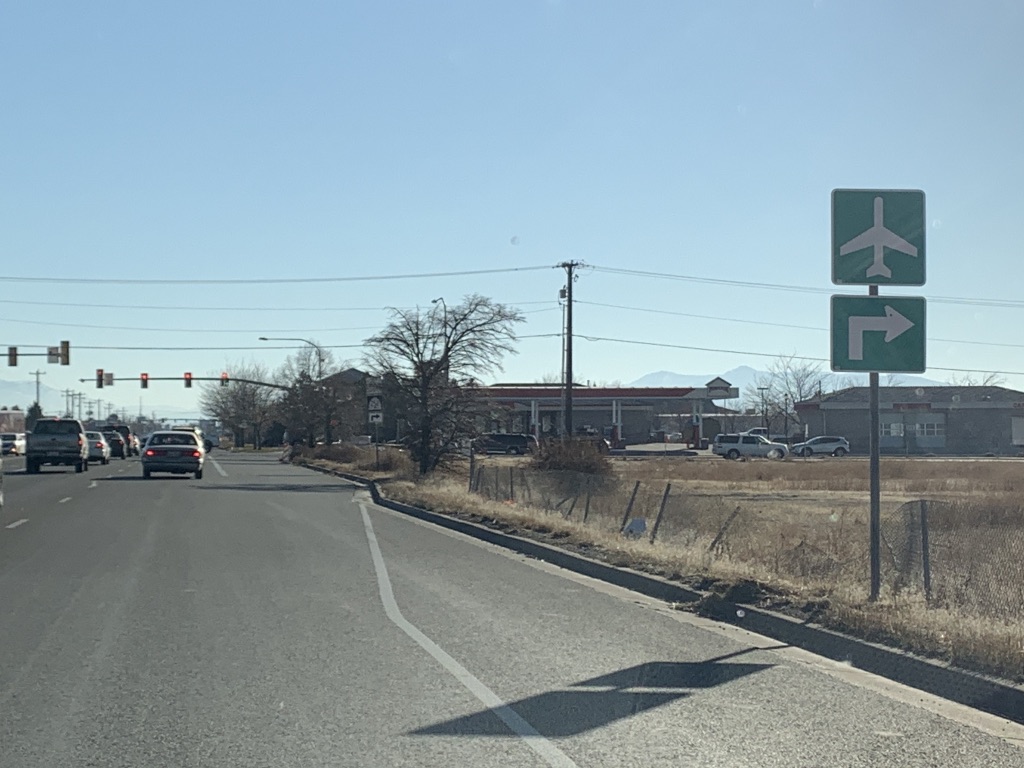
| Now in North Logan, turn right for Benson, Tremonton, and Brigham City. |
 |
| And the Logan-Cache Airport. |
 |
| SR 252 begins to the right. The JCT banner shouldn't be there. |
 |
| SR 252 is actually a western bypass of Logan, which is huge as the downtown district tends to see frequent heavy traffic. Unfortunately, it's not signed that well - while technically listing Brigham City as a destination is good enough, it would be very useful if Ogden or Salt Lake City were also listed on that sign. |
 |
| US 91 reassurance. |
 |
| US 91 follows Main Street through Logan. |
 |
| Another US 91 reassurance entering Logan proper |
 |
| Stay straight for visitor info. |
 |
| At 400 North, US 89 and no-longer-signed SR 30 will come in from the east and join up with 91. |
 |
| In another block, stay straight for US 89 and 91 south. A signed segment of SR 30 will turn off to the right. |
 |
| Use SR 30 for Tremonton and US 89-91 for Brigham City. |
 |
| Hmm. UDOT pulling a New Mexico here...not sure I like it. |
 |
| 89 and 91 reassurances after 30 splits off. |
 |
| These double-outline US markers are actually pretty cool, and there used to be quite a few on the segment of 89-91 between Logan and Wellsville. Unfortunately most of them have been replaced. |
 |
| At the southern end of downtown Logan, stay in the left lane for SR 165. |
 |
| Use 165 for Providence and Hyrum, 89-91 for Brigham City and Salt Lake City. |
 |
| 165 splits off ahead. This type of LGS (little green signage) isn't often used in Utah. |
 |
| A bit of a confusing junction, this was reconfigured within the last few years. The light ahead for southbound 89-91 through traffic is new with that reconfiguration, so it gets a "prepare to stop" warning. |
 |
| Wellsville, Brigham City, and Salt Lake City all lie ahead. |
 |
| We'll reach the other end of the SR 252 bypass. |
 |
| SR 252 begins to the right. |
 |
| As per the usual for newer UDOT traffic lights, the street sign includes both street name and route shield. |
 |
| In recent years, UDOT has frequently dropped the dash between "US" or "SR" and the route number. This is likely why. Previously, the signs at most lights along the 89/91 overlap only had US 91. |
 |
| Southbound concurrency signage with a big gap between the 9 and 1. |
 |
| After proceeding further southwest, we'll junction SR 101. |
 |
| SR 101 goes east to Hyrum or west to Wellsville. |
Then we'll shift to northbound photos from Mantua to Wellsville:
 |
| Although we've already passed the main Mantua exit from the south, there's another turnoff coming up in a half mile. |
 |
| Turn right for Mantua. |
 |
| US 89/91 reassurance leaving Mantua. |
 |
| From here, the four-lane highway leaves Mantua Valley and begins to ascend Dry Canyon. |
 |
| We'll get a mileage sign to Wellsville, Logan, and Bear Lake. |
 |
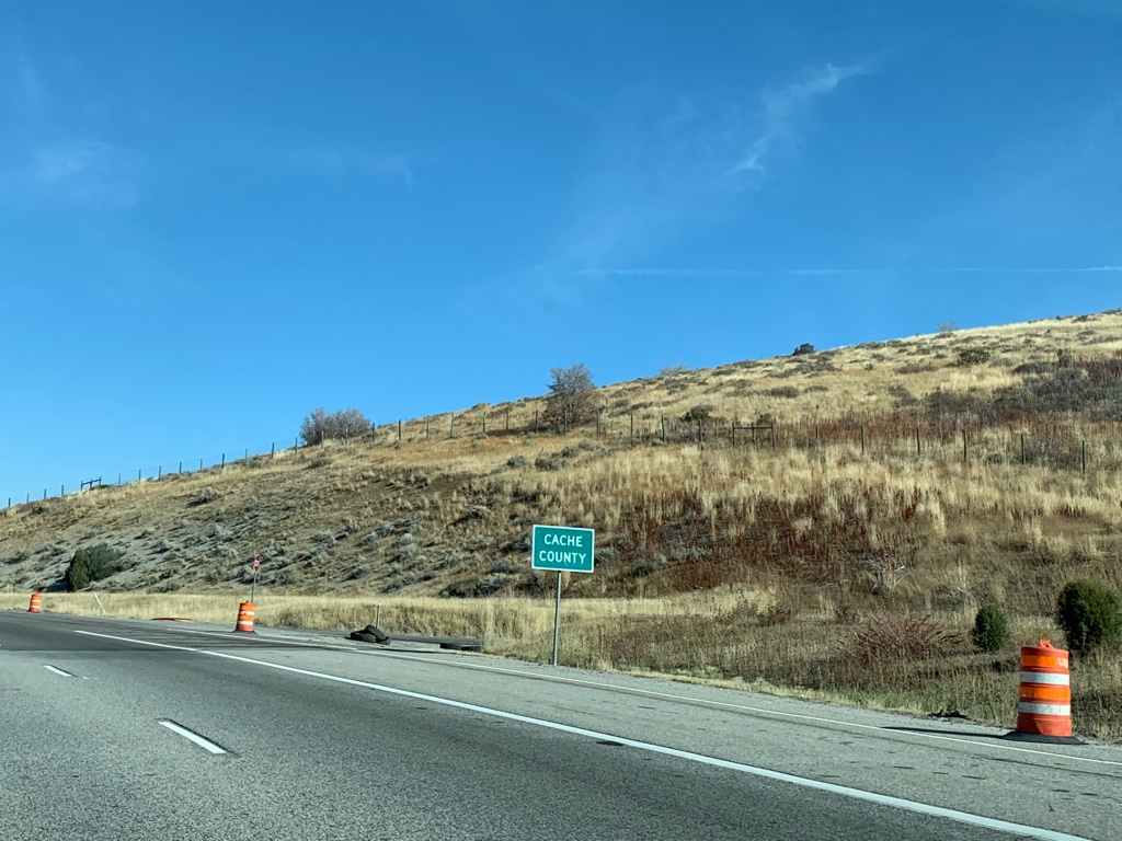
| At the 5981-foot Sardine Summit, US 89/91 enters Cache County. |
 |
| Another reassurance shield appears as we begin the descent. |
 |
| The four-lane divided highway runs across Dry Lake. In spring, this fills up with water, but in October it was a flat plain. |
 |
| After making the final descent from Wellsville Canyon, the highway opens out into the Cache Valley with the Bear River Range in the background. |
 |
| Wellsville is a city of about 4000 people. US 89/91 used to pass directly through it, but now follows a southeastern bypass. |
 |
| Coming up is the junction with SR 23. |
 |
| Stay straight on 89/91 for Logan; turn left on 23 for Wellsville and Mendon. |
 |
| Also keep going straight for Utah State University, which is located in Logan. |
 |
| SR 23 begins to the left. The cross street is the pre-1950s alignment of US 91. |
Finally, we'll head south from Mantua:
 |
| Coming into Mantua from Dry Canyon, stay in the left lane to turn to Mantua in 1/2 mile. |
 |
| That's also how one gets to the Box Elder Campground. |
 |
| Turn left for Mantua and the Box Elder Campground. Unlike the northbound direction of US 89/91, which has a partial exit south of town, this is the only southbound access to Mantua. |
 |
| Reassurance shields after the junction. |
 |
| Another set of reassurance shields, this time after the southwest Mantua partial interchange merges in. |
 |
| Brigham City is 1 1/2 miles ahead, while Ogden and Salt Lake City are much farther. I can't think of another mileage sign like this in Utah with a fractional distance. |
 |
| The descent into Brigham City is rather steep, so all trucks over 10,000 pounds must stop at a brake check area before heading down towards I-15. |
 |
| Coming up on another partial interchange, but this time in the opposite direction. |
 |
| Quite a bit of warning for a traffic light, but I'd imagine it's justified. We've been on a high speed freeway/divided expressway for some time now. |
 |
| If your brakes already died, there is a runaway truck ramp for you coming up. |
 |
| Trucks are required to slow to 40 mph on the final descent. |
 |
| SR 90 exits to the main part of Brigham City, while we'll turn off onto the southwestern bypass. 90 is the original alignment of US 89 and 91. |
 |
| The brake check area is coming up... |
 |
| ...and so is the runaway ramp. |
 |
| More warning for the upcoming traffic light at US 89/SR 13. I don't think I've ever seen another overhead permanent flashing beacon in Utah. |
 |
| JCT 89 is a bit misleading, because we're already on US 89. The 13 is legit, though. |
 |
| Stay straight on US 91 for Tremonton, Salt Lake, and Ogden - all via I-15. Depending on what part of Ogden you're headed for, it might actually be better to turn left here and take US 89 down. |
 |
| Use US 91 to I-15/84. Notice the WEST banner, even though US 91 is a north-south route. |
 |
| US 89 turns off to the left, SR 13 begins to the right. |
 |
| Another WEST 91 reassurance shield. For whatever reason, UDOT consistently signs this 2-mile section of US 91 as east-west. It does go east-west, but it should be signed north-south to match the rest of the route. |
 |
| Turn right for an armory. |
 |
| After a couple miles, we'll come to a junction with I-15/84. |
 |
| Turn right on I-15 north/I-84 west for the Golden Spike National Historical Park and the Bear River Bird Refuge. |
 |
| Turn right for I-15 to Pocatello and I-84 to Twin Falls. |
 |
| This interchange was upgraded in 2014 to the Utah's first diverging diamond interchange north of Salt Lake. |
 |
| Stay left for I-15 south/I-84 east to Ogden. If I were UDOT, I would have signed Salt Lake City in some capacity at this interchange. |
 |
| US 91 ends. |
SR 38
All photos taken May 2019.
 |
| SR 38 begins at SR 13 in Brigham City and heads north on Main Street, |
 |
| From here, it is 8 miles to Honeyville, 14 miles to Deweyville, and 34 miles to Logan. |
 |
| In the city of Honeyville, SR 38 junctions SR 240. |
 |
| SR 240 is a short route that connects SR 38 at Honeyville to I-15. 15 is also I-84, but that is omitted from this sign. |
 |
| Reassurance after that junction. |
 |
| Continuing on to the town of Deweyville, we'll junction with SR 102. Between 1966 and 1991, this was the northern terminus of SR 69; SR 30 came in on what is now 102 and went north from here. |
 |
| Heading out of Deweyville, Collinston is 4 miles ahead; Logan is 16 miles further up SR 30. |
 |
| SR 38 begins to climb out of the Malad Valley and onto the foothills of the Wellsville Mountains, where the unincorporated community of Collinston is located. |
 |
| Just past what could be considered the town center, the highway has a fork at SR 30. The configuration of this junction is inherited from when SR 30 went through Deweyville, and SR 69 before that. Stay straight for Logan or left for Riverside. |
 |
| SR 38 ends here. Staying straight or making a left here will put you on SR 30. |
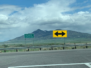 |
| If you make that left, you'll come to a stop sign at actual SR 30, where you can turn left for Fielding and Riverside. |
SR 90
All photos taken May 2019.
 |
| SR 90 begins at a partial interchange at US 89/91. 90 was the routing of both US highways before the modern bypass was built. |
 |
| Reassurance shield as we descend the hill to Brigham City. The lack of a directional banner, along with the shield design, suggests this is an older assembly. |
 |
| Brigham City signed this whole section as 200 South Sr 90. I'm not sure I've ever seen a route designation written that way before. |
 |
| As it approaches the center of town, the highway will junction SR 13, where you can turn right for the Golden Spike National Historical Park. Back in the day, US 89 and 91 turned left here, US 30S went either direction, and US 191 began to the right. |
 |
| These even older shields mark the end of SR 90. Turn right for an RV dump. |


No comments:
Post a Comment