For this post, we'll return to the urbanized areas of Utah and discuss some of the east-west routes in the mid-southern part of the Salt Lake Valley. Today, we'll focus on the routes that have served the general region between the Kennecott Copper Mine, the Midvale/Sandy area, and the mouth of Little Cottonwood Canyon.
SR 48 and the Copper Mine
The first route branching off US 91 (now US 89) in this area was
SR 48, created in 1927:
48. From Midvale Junction to Bingham.
Midvale Junction was the intersection of State Street (US 91) and Midvale's Center Street (7720 South). From there, 48 headed west on Center, which became 7800 South upon exiting Midvale. Then it turned on what is now called the Old Bingham Highway - probably just the Bingham Highway back then - running southwest and west to Copperton. The Old Bingham Highway is not drivable as a continuous road today due to a discontinuity at 9000 South, but it connected in 1940:
 |
| US Census, 1940. |
From there, SR 48 continued southwest to the city of Bingham Canyon, where it ended at the north city limits. Bingham Canyon was the most substantial mining town in the Oquirrhs, housing personnel for the Bingham Canyon open-pit copper mine (the largest of its type in the world). The following USGS map does not show the terminus correctly (it has the 48 designation continuing too far south), but it shows the Bingham Canyon city limits and what the town looked like:
 |
| USGS (Bingham Canyon), 1952. |
Interestingly, the 1950 Shell map showed a portion of 48 in Tooele County:
 |
| Shell (Utah), 1950. |
If that map were to be believed, SR 48 was extended west over a yet-to-be-built roadway through the Oquirrh Mountains to Middle Canyon Road, then west into Tooele. However, this change does not appear on any other maps from that time period, nor is it indicated in any highway resolutions or legislative descriptions (which often were changed before roads were actually built). So I'm going to say this is an error.
At some point around 1950, the route was adjusted in the Salt Lake Valley as well. SR 48 no longer used the Old Bingham Highway; instead, it continued further west on 7800 South before turning southwest on a new road, naturally called the New Bingham Highway, meeting up with the old route just east of Copperton. This change appears on USGS maps as early as 1951. Here's a 1959 map that shows all of 48:
 |
| USGS (Utah), 1959. |
By 1968, Bingham Canyon was beginning to shrink as a mining town, and the size of the city limits had been decreased as a result. So in order to keep the west end of 48 at the city limits, the route was extended southwest 0.3 miles.
But since then, the Bingham Canyon Mine has continued to expand, and the west end of the state highway has been truncated several times as the mine grew bigger and bigger. By 1973, the mine had essentially wiped out the entire Bingham Canyon town. Kennecott, the company that owned the mine, requested to move its guard station to a point 1.25 miles east of the SR 48 terminus. UDOT denied that request, but agreed to abandon SR 48 west of that point on the condition that Kennecott assume responsibility for that segment. Kennecott agreed, and the endpoint was moved to a location described as "1.8 miles west of the Copperton post office".
Here's a map from the 1973 State Road Commission resolution. Red indicates a roadway removed from the state system, while blue shows a removal from the federal aid secondary system - in this case, simply abandoned.
 |
| Utah State Road Commission, 1973. |
That lasted until sometime between 1997 and 2004 (likely sometime around 2000). At that point, another 3/4 mile or so was shaved off, bringing the western terminus about a mile west of Copperton. And then around 2012, it was truncated again to just west of the Copperton township limits.
If you think all that is confusing, you're not alone. Here's a map showing the incremental truncations of the state highway through Copperton, as I understand them:
That also serves as a commentary on just how big the copper mine got. The farthest terminus was once the site of a town of 15,000 people. Today, the entire town and three miles of state highway have been completely wiped out.
The Coming of the Interstates
In the mid-1960s, I-15 was being constructed through the central Salt Lake Valley. The new interstate would not include an interchange at Midvale's Center Street; rather, the Midvale interchange was placed at 7200 South. So in 1965, in order to serve the new interchange, the east end of SR 48 was moved to State and 7200 South, running west from there through the I-15 interchange. It connected back to the previous Center Street alignment by way of Midvale's Main Street and Holden Street. That alignment can be seen on the map below.
The next interchange south on I-15 was placed at 9000 South. In order to have a state highway serving this interchange, at the same time as SR 48 was moved, the State Road Commission designated a new SR 177, which ran along 9000 South through the new interchange from Redwood Road (SR 68) to State Street (US 89, then also US 91).
Four years later, in 1969, another route was added in this area, this one connecting State Street in Sandy and SR 210 at the mouth of Little Cottonwood Canyon. Numbered SR 209, the new route followed 9400 South and Little Cottonwood Road.
All three adjustments can be seen on this 1978 map:
Later eastern realignments
SR 177 and 209 were clearly intended to function as one east-west corridor, and in most states, they probably would have been one route with a four-block concurrency on US 89. But given Utah's track record with avoiding concurrencies, it's unsurprising they ended up as two different routes.
But in 1987, a new road was built extending 9000 South a few blocks beyond 700 East, then shifting south onto the existing 9400 South alignment. The full east-west highway from Redwood Road east on 9000 South, southeast on the new road, and east on 9400 South to Little Cottonwood Canyon was designated SR 209. This western extension of 209 fully absorbed SR 177, which was deleted at that time. In addition, the segment of 9400 South between State Street and the new SR 209 alignment was removed from the state system, as it had been replaced by the new 9000 South alignment.
But UDOT wasn't done making changes in this area. In 1998, a new bridge over the Jordan River was built on a new road connecting 7000 South at Redwood Road with 7200 South at 700 West (Midvale Main St). This new road was named Jordan River Boulevard. In 2000, SR 48 was moved to use Jordan River Blvd and 7000 South west all the way to Redwood Road, where it turned south along an implied concurrency with SR 68 (!) to 7800 South, where it resumed its earlier alignment. Main Street, Holden Street, Center Street, and 7800 South east of Redwood were all turned back to their respective cities at that time.
Here's a 1999 map showing the pre-2000 alignment through Midvale, as well as the roadway that would become SR 48 the next year:
 |
| USGS (Midvale), 1999. |
Extending 9000 South
UDOT still wasn't done, though, and plans called for extending 209 further west. In 2005, the western terminus in SR 209's legislative description was revised to "Route 48", which would have extended 209 west on 9000 South to a junction with the New Bingham Highway. However, most of that road didn't exist yet; 9000 South ended at the Old Bingham Highway at the time. So despite the description change in 2005, because 9000 South didn't connect through yet, SR 209 was never actually extended past Redwood. By 2009, 9000 South was continuous through to 5600 West, but didn't yet connect to SR 48.
When the connection to SR 48 was finally made in 2012, it took a slightly different form than had been expected previously due to the construction of the Mountain View Corridor. With the new configuration, 9000 South was extended west through an intersection with the Mountain View Corridor and now tied directly into the New Bingham Highway towards Copperton, while the New Bingham from the east was cut off at 5600 West.
 |
| USGS (Copperton), 2014. |
As a result, SR 48 was moved to use 9000 South (through the Mountain View intersections) and 5600 West to connect between the two surviving portions of the New Bingham Highway.
But that arrangement only lasted three years. In 2015, SR 48 was truncated all the way back to Bangerter Highway, with 209 finally getting its long-planned western extension - all the way to the copper mine, replacing 48 west of 5600 West. The remaining portions of SR 48 (on 5600 West and the eastern half of the New Bingham Highway) were removed from the state highway system.
Here's a map from the relevant Utah Transportation Commission resolution. Here, blue represents the portion of 209 added to the state system in 2015, green indicates the portion of 48 renumbered to 209, and red is used for the decommissioned part of SR 48.
 |
| Utah Transportation Commission, 2015. |
Route Photos
All photos on this page taken June 2020.
SR 48
 |
| The first SR 48 reassurance shield as we head west from State Street. |
 |
| The highway crosses the UTA TRAX light rail system's Blue Line, which runs along the former UP right of way. |
 |
| That used to say "Fall 2020" but now reads "End of 2020". I guess COVID slowed down the project. |
 |
| Turn right for I-15 north to Salt Lake and the I-215 Belt Route. Make a left for I-15 to Las Vegas. |
 |
| SR 48 passes under a set of several bridges: the one in the foreground carries the on-ramp from I-215 to I-15 southbound. In the background are a pair of railroad bridges carrying the Union Pacific Railroad and FrontRunner commuter rail. Behind the camera are two more bridges: one carrying I-15 itself, the other the ramp from I-15 northbound to I-215. |
 |
| The highway crosses under another railroad bridge, this one carrying the TRAX light rail's Red Line. That right-of-way (and this bridge) started out as a Union Pacific spur to a smelter. |
 |
| Stay straight for SR 48, instead of turning left on 700 West like 48 did in the past. |
 |
| Stay straight to follow 48 to "Municipal Airport 2". That's the general aviation field serving the Salt Lake Valley, and it used to actually be called Salt Lake City Municipal Airport 2. It's now South Valley Regional Airport. |
 |
| Interestingly, this sign still directs travelers to turn left here to get to the copper mine. I wonder if this sign is a holdover from the days when 48 did turn here. The wooden sign and all-caps lettering suggest that may in fact be the case, and if it is this sign has held up rather well. |
 |
| 7200 South bears the alternate name "Jordan River Boulevard" in this area. |
 |
| Turn right for Bingham Junction Park. |
 |
| No UDOT-spec sign, but this decorative sign welcomes us to West Jordan after crossing the Jordan River. |
 |
| Turn right for a West Jordan City Park. |
 |
| Not far ahead, we'll get signage telling us to turn left for the municipal airport. |
 |
| That left turn is going to be onto SR 68, or Redwood Road. |
 |
| SR 48 turns south on a concurrency with SR 68. There is some debate in road enthusiast circles over whether or not concurrencies like this exist or whether 48 is just discontinuous - but as far as I'm concerned, this signage establishes that a 68/48 overlap does in fact exist. |
 |
| After making that turn on Redwood, head south for the airport. |
 |
| Unfortunately, Utah does not sign its concurrencies well, so there is no SR 48 dual reassurance shield here. |
 |
| A mile ahead, SR 48 turns right and resumes its westward journey on 7800 South. |
 |
| SR 48 reassurance after making the turn. |
 |
| Turn left for another West Jordan city park. |
 |
| Stay straight for the Thru Truck Route to the Trans-Jordan Landfill. |
 |
| The original alignment of SR 48 turned left here onto the Old Bingham Highway. However, it continues west on 7800 South today. |
 |
| Not long past that, the highway comes to a junction with SR 154, better known as the Bangerter Highway. |
 |
| Turn right for 154 north, left for 154 south. This is a single-point urban interchange. |
 |
| 48 ends just past the interchange. |
SR 209
 |
| SR 209 begins just west of Copperton, passing beneath this bridge of sorts |
 |
| 209 then enters the metro township of Copperton. |
 |
| In Copperton, 209 is known as "State Highway". |
 |
| Unfortunately, this railroad bridge is no longer in use. But it looks cool. |
 |
| Bear left onto the New Bingham Highway towards West Jordan. The road off to the right is the Old Bingham Highway, which was SR 48 before 1950. |
 |
| From here, the New Bingham Highway descends northeastward into the Salt Lake Valley. |
 |
| The first state highway to junction 209 is SR 111. |
 |
| SR 111 begins to the left here. Contrary to what you might see on some maps, the road to the right here is NOT 111 and hasn't been since 1969. |
 |
| Turn left for 111 to Magna, right for ex-111 to Herriman. |
 |
| A few miles ahead, you can turn left for the West Jordan animal shelter and Ron Wood Park. Those are located on a bypassed segment of the New Bingham Highway, also an old alignment of SR 48. |
 |
| SR 209 veers to the east onto 9000 South and comes to a split intersection at the Mountain View Corridor (SR 85). |
 |
| Stay straight for 85 north, turn right ahead for 85 south. |
 |
| Same as above, but stay straight for 209 east. |
 |
| At the other half of the split intersection, turn left for Mountain View northbound. |
 |
| Stay straight at 5600 West to continue on 209 east. This sign is here because when SR 48 ran through here before 2015, it turned left here to connect back to the New Bingham Highway |
 |
| This segment of 9000 South was constructed new in the 2000s. No driveways and very few side road intersections...but of course, the speed limit is still 40 mph. |
 |
| Turn right for the Old Bingham Highway, which was split up in order to build the 9000 South connection. |
 |
| Notice the West Jordan city logo on the street blade. This is the only intersection I've ever seen this at, and I almost wonder if it's a UDOT sign since the corresponding blades for 9000 South have SR 209 shields. |
 |
| Not far after that, SR 209 will junction Bangerter Highway (SR 154). |
 |
| Turn right for 154 south, bear left for 154 north. |
 |
| Like some of the other busy intersections on Bangerter, this one has been upgraded to an interchange. |
 |
| At 3400 West we can turn left to reach a hospital. |
 |
| 209 continues east on 9000 South, with great views of the Wasatch Mountains. |
 |
| In eastern West Jordan, SR 209 intersects SR 68. |
 |
| Turn for 68, stay straight for 209. Before 2015, this was the western terminus of SR 209, and before that, SR 177. |
 |
| Reassurance for 209 after Redwood Road. Note the older shield - unlike the section west of Redwood, this has been SR 209 since the 1980s, so there's a bit more opportunity for some older shields. |
 |
| After crossing the Jordan River, we'll exit West Jordan and enter Sandy. |
 |
| Turn right for a golf course, in this case River Oaks. |
 |
| At 700 West, get in the left lane if your goal is I-15 north. |
 |
| Just west of the interstate, we'll intersect Sandy Parkway. That runs south from here to South Jordan, where it is better known as Jordan Gateway. |
 |
| Use I-15 north to Salt Lake and south to Las Vegas. |
 |
| Like most other I-15 interchanges throughout the Salt Lake Valley, this is a single-point urban interchange. |
 |
| Not far after I-15, the highway reaches US 89. Turn right there for the Mountain America Expo Center and Rio Tinto Stadium. |
 |
| US 89 is better known as State Street. |
 |
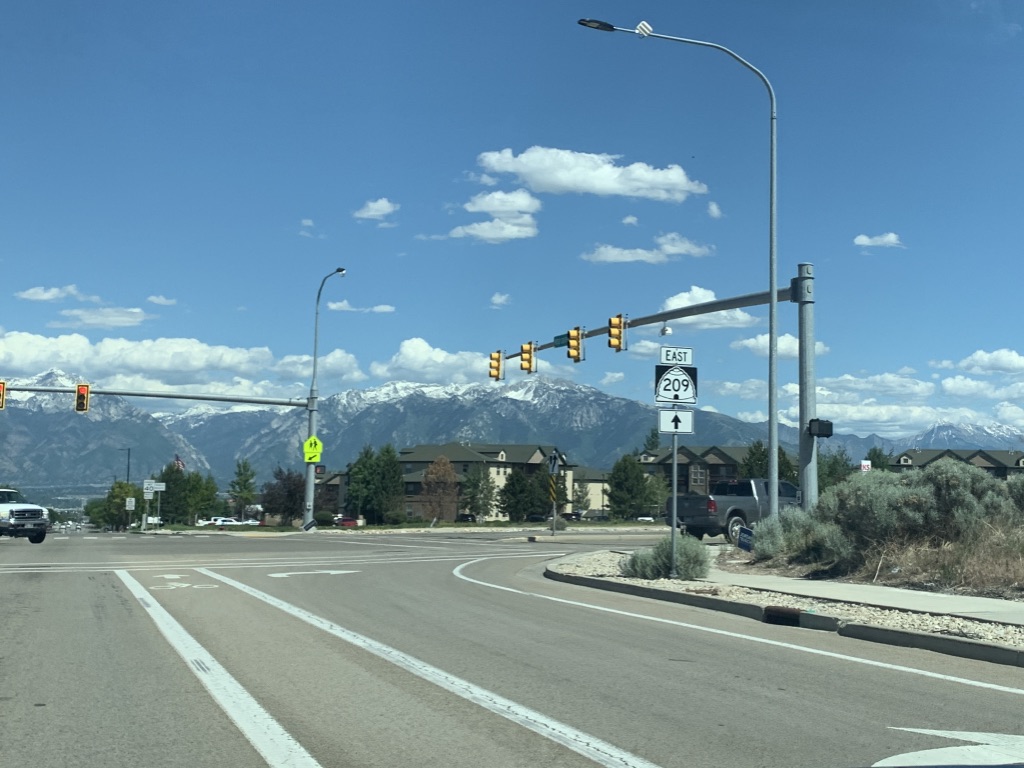
| 209 reassurance after US 89 |
 |
| 209 crosses the UTA TRAX Blue Line |
 |
| The next state highway junction is at 700 East, which is SR 71. |
 |
| Another 209 reassurance after SR 71 |
 |
| As we veer to the southeast, we'll pass through a seagull intersection. I've never seen the double red arrow in Utah at all - much less on a flashing yellow arrow assembly! |
 |
| Here we meet up with the original alignment of SR 209, which is now better known as just 9400 South. To avoid confusion, the road we're on is signed simply as "SR-209". |
 |
| As we continue towards the mountains along 9400 South, we'll start getting a ton of ski area-related signage. Here's the first one, telling us to continue east to the ski areas. |
 |
| This sign informs ski bus users whether various park-and-ride lots are full. |
 |
| Turn right here for the 9400 South/2000 East park and ride |
 |
| Getting closer to the Wasatch, we'll depart from the straight alignment of 9400 South where the name changes to Little Cottonwood Road. |
 |
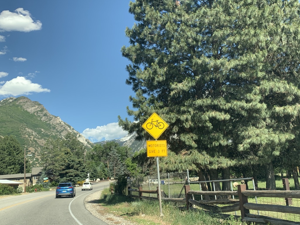
| This road also features a fair amount of bike traffic - this sign reminds motorists to give 3 feet of clearance to bicycles. |
 |
| During winter, this electronic sign lights up whenever SR 210 through Little Cottonwood Canyon is closed for avalanche control. |
 |
| Stay straight on 209 for Snowbird and Alta, 8 and 10 miles up Little Cottonwood. Turn left on Wasatch Blvd for Solitude and Brighton, 15 and 18 miles away up SR 190. |
 |
| At every side street along Little Cottonwood Road between Wasatch Blvd and Little Cottonwood Canyon, there is a "do not block intersection" sign. Why? Because ski traffic in winter often congests this road to stopped bumper-to-bumper traffic. |
 |
| 209 crosses Little Cottonwood Creek on one of the oldest bridges in the county. |
 |
| Snow tires or chains are required for vehicles traveling up Little Cottonwood Canyon from October through April. |
 |
| Continue straight for another park-and-ride. |
 |
| Turn right at SR 210 for Snowbird and Alta. |
 |
| SR 209 ends here without signage at SR 210. Turn left for that park and ride. |


