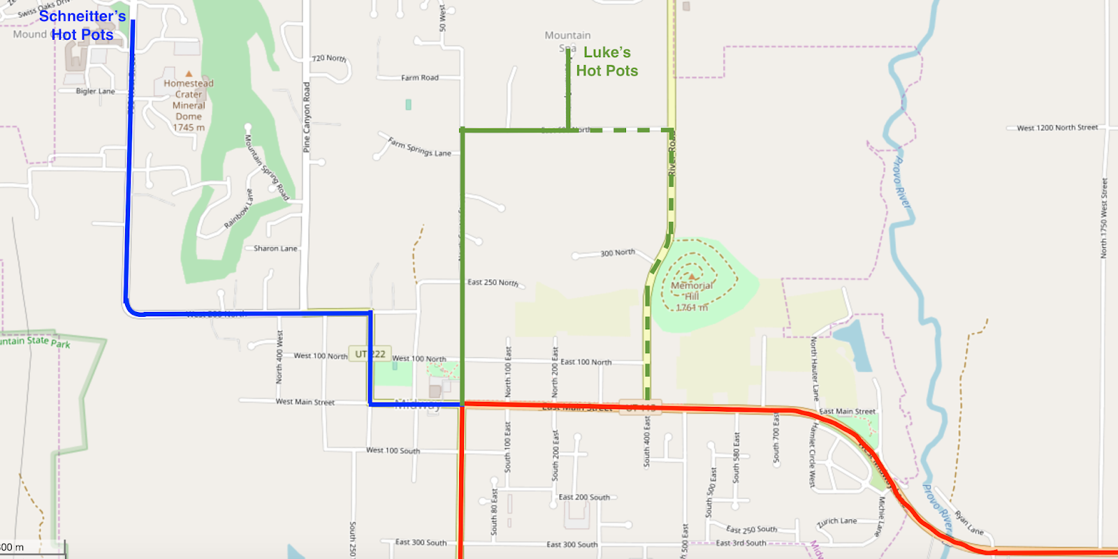
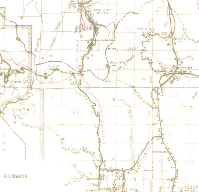
Here's my own interpretation of that map, zoomed in a bit more on Midway. I made that map before I had access to the 1958 map above, so the dotted line represented the possibility of a 225 alignment along River Rd.
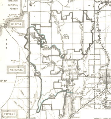
In 1961, Wasatch Mountain State Park was established just northwest of Midway. It is one of the few state parks not related to a large body of water like a lake or reservoir, but that doesn't stop it from being the most developed and one of the most popular parks in Utah. Soon after its initial creation, the State Road Commission added several roads near and within the park to the state highway system. The most prominent addition was SR 224: in 1963, that route was extended north from its previous endpoint at Schneitter's up Pine Canyon to Bonanza Flat, then over Empire Pass and down into Empire Canyon, through Park City and all the way to Kearns Boulevard, where it ended at SR 248 (which may or may not have been Alt US 40 by that point). This extension fully absorbed SR 97. At the same time, SR 152 was extended east from its previous endpoint at Guardsman Pass to a new junction with 224 in Bonanza Flat. Those additions were shown on this map attached to the Utah State Road Commission resolution:
 |
| USRC, 1963. |
SR 224 would be extended even further north six years later in 1969, over the western half of SR 248, to a new northern terminus at Kimball Junction. This was initially at US 40, but within a few years, I-80 was completed, and 40 would be truncated to Silver Creek Junction in 1975.
At the same time as 224 was designated, SR 225 to Luke's Hot Pots was removed from the state highway system, possibly as an indicator that tourist destinations in Wasatch County were shifting from the hot springs in the valley to the mountains above. That continued with the designation of SR 220 a few years later in 1966, covering the southwestern portions of the new mountain state park. If it had been created just ten years later, it probably would have received a number in the 300s as a dedicated state park road, but that concept didn't exist yet in the 1960s.
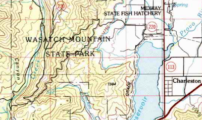
Essentially, 220 was designed as a big loop from the western portion of the Heber Valley through the mountains. The loop began at SR 113 about halfway between Midway and Charleston and headed west on Tate Lane. After briefly jogging north on Stringtown Rd, it went southwest on Cascade Springs Road towards Cascade Springs. From there, it went north on Cummings Parkway, then southeast on Snake Creek Road back into Midway, ending at SR 224 at Warm Springs Road. The best map of 220 I could find is the one from the resolution creating it:
 |
| USDH, 1963. |
As that map shows, the loop road passed within the Uinta National Forest for a mile or so; that portion was specifically left out of SR 220 (clearly UDOT was not interested in pursuing a jurisdictional transfer with the federal government). So basically, the big loop consisted of two discontinuous pieces of SR 220 with a segment of Uinta National Forest road connecting them.
It should also be noted that the vast majority of this 1960s new mileage in the mountains on 220 and 224 consisted of unpaved roads that were not plowed in winter. They were also no stranger to realignments. At some point early on, probably in or before 1969 based on historic aerial imagery, 220 was moved to directly serve Cascade Springs, which is where Cascade Springs Drive meets up with Provo Deer Creek in the bottom left corner of the map below. From there, 220 followed Deer Creek northward for a bit, then switched back to climb the hill and join up with the original route at the top of the ridge (that junction is right under the second A in "WASATCH" on the map below). This would have resulted in a longer route, but Cascade Springs was and still is a fairly significant destination.
 |
| USGS (Provo), 1986. |
If that sounded complicated, SR 224's realignment history is far worse. When 224 was extended in 1963, the road from the Bonanza Flat junction over Empire Pass was slightly north of its current location, and crossed the Empire Pass ridgeline itself slightly further west. This can be seen on old USGS topographic maps, where new alignments were often simply drawn in a different color without necessarily changing the old ones. On the map below, newer roads were drawn in purple colors on top of the older ones in black:
 |
| USGS (Brighton), 1978. |
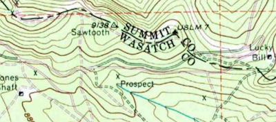
According to Historic Aerials imagery, in 1962, the year before SR 224 was extended over this pass, the Wasatch County approach followed that northern (black) alignment, crossing the county line just right of the "O" in SUMMIT CO. However, that last switchback on the Summit County side by the Lucky Bill mine was in place by then, so 224 would initially have followed the dotted black line east to connect into the hairpin. The modern, more southerly alignment on the Wasatch County side with its further-east Empire Pass crossing was implemented sometime between 1967 and 1978. The old alignment is still in use as a hiking trail.
To understand the messier history of the route around Park City itself, we'll need a brief geography lesson. Park City is located at the base of two canyons that head south into the mountains, both of which were home to major silver mines. On the west is Empire Canyon, with Daly Avenue running along the bottom, and on the east is Ontario Canyon with Marsac Avenue. The two canyons are split by Ontario Ridge higher up, but eventually merge into a slightly broader valley. The historic Park City center is where Silver Creek, flowing from meadows in neighboring Frog Valley and Deer Valley to the east, joins this valley.
As discussed above, the original SR 97 alignment used Empire Canyon to leave Park City to the south. When 224 was extended into Park City in 1963, it descended from Empire Pass more or less along the crest of Ontario Ridge, then descended via switchback to the mines in Empire Canyon before proceeding south into Park City. This road passes right through the junction of four 1:24000 USGS maps: the map below is my attempt to merge them into one. They aren't all from the same year, as evidenced by the differing route designations, but this is a pretty good idea of what it looked like:
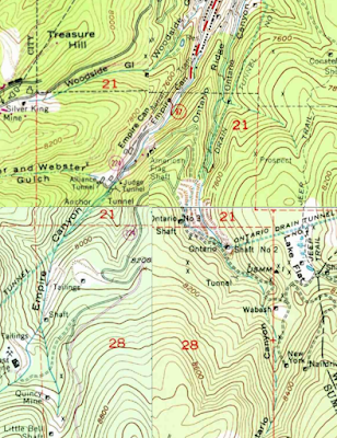 |
| USGS (Park City West/Park City East/Brighton/Heber City), 1970s. |
At some point during the late 1960s or early 1970s, the Empire Canyon descent was abandoned in favor of a new descent down Ontario Canyon. Instead of following Ontario Ridge down, 224 looped around to the east, to the Ontario mine shafts, and then followed Marsac Avenue north down the bottom of the canyon into Park City. Once in town, it used Hillside Avenue to descend to the original alignment along Main Street. According to the
1984 Park City streets master plan, Marsac was paved and open year-round below the Ontario mine.
You might notice that although the maps above date from the 1970s, they don't show that realignment. And in fact, it was exceptionally poorly documented for decades: detailed maps as late as 2001 were still showing a state highway up Daly Avenue, and the geometry on UDOT's greater Wasatch Front inset map suggested the Daly alignment until 2012! But we do know it moved to Marsac at some point before 1973 - because that year, UDOT and Park City agreed to move SR 224 to a bypass through the southern downtown portion of Park City. 224 was moved onto Marsac Avenue south of Heber Avenue, removing Main and Hillside from the state highway system. So clearly 224 had been moved to enter town on Marsac at some point before then.
 |
| USDH, 1973. |
The 1974 legislature formalized that change.
By this time, mining was in serious decline in Park City, with activity continuing pretty much only at the Ontario mine, ending in 1982. But with the decline of mining came the rise of another industry: skiing. This had been a known activity in this area since 1936, when a "Winter Carnival" was held in Deer Valley, and the Works Progress Administration (WPA) built several ski runs, courses, and jumps in the area the following winter. In 1946, two entrepreneurs constructed a lift on the Deer Valley hillside and called it Snow Park Ski Area. This was very much a local endeavor - they built the lifts from nearby trees, and they often broke, but it did see some success. By the 1950s, mining had declined enough that United Park City Mines (UPCM), which owned most of the mines that were still active, began looking into skiing as a potential money-making venture, no doubt inspired by the local Snow Park area and also similar development of old mining towns in Colorado, such as Vail and Aspen, into ski areas. So in 1963, UPCM had opened the Treasure Mountain ski area above Park City, which became Park City Mountain Resort a few years later. In 1968, a new resort opened on the west side of 224 about halfway between Park City and Kimball Junction. Initially known as Park City West, it was known as ParkWest for years before eventually becoming The Canyons. And in 1981, Deer Valley opened on the site of the old Snow Park area.
As you might guess, all this brought quite a bit of tourist traffic to the Wasatch Back. Probably in order to avoid overwhelming historic downtown Park City, a new bypass around the remainder of the historic downtown district was constructed in the early 1980s. The new road, called Snow Country Drive, would run from the existing Heber/Marsac intersection around the northeast side of town to a junction with Park Avenue. In 1984, SR 224 was moved to this road:
 |
| UDOT, 1984. |
Some realignments took place with the existing roads at the east end. In particular, the bypass was combined into one road with Deer Valley Drive heading east to the base of the Deer Valley resort, with Marsac splitting off to the south. Heber Avenue was disconnected from Marsac on the east side; instead, it now ended at Swede Alley, which was extended to the northeast to connect with the new bypass just north of the Marsac intersection.
 |
Google Earth, 1993.
|
Snow Country Drive and the segment of Heber Avenue east of Marsac are now known as Deer Valley Drive, after the ski resort to the southeast, but this bypass remains the route of SR 224 through the Park City downtown area today. 224 has also since been expanded to a five-lane configuration everywhere from downtown Park City north to I-80.
So zooming out for a second - here is what that general area looked like in 1986:
 |
| 1986, unknown source |
It wouldn't look like that for long, because just a few years later, the Jordanelle Dam would be built, bringing major realignments for both US 40 and 189 and a cascading series of changes to other state roads in the area. The full story is one for another post, but as far as the roads we've talked about here are concerned, there ended up being a pretty significant mileage swap between UDOT and Wasatch County in 1990. Essentially what happened was in exchange for the modern roadway from Heber to Francis becoming part of SR 32, all of the Wasatch County mileage on those mountain state park routes that had been added in the 1960s was removed from the state highway system. A map from the transportation commission resolution approving these changes is shown below:
 |
| UDOT, 1990. |
All highlighted routes above were removed from the state system. The red, orange, and green segments are respectively portions of SR 220, 224, and 190 (previously 152) that were given directly to Wasatch County to maintain. The yellow roads were portions of SR 220 within Wasatch Mountain State Park, which were presumably transferred to the jurisdiction of the state parks department.
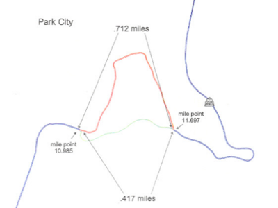
This had the effect of decommissioning SR 220 entirely, and SR 190 now terminated at the county line at Guardsman Pass. But 224 still had that original section in Midway - so now there were two discontinuous segments of SR 224: one running from SR 113 in Midway north to Pine Creek Campground, and another from the Summit/Wasatch County line north to Kimball Junction. The 224 segment in Summit County between the county line and the Ontario Mine (more specifically, the junction with the road now called Wheaton Way) had probably been paved by this point but certainly remained closed in winter.
SR 224 would maintain this discontinuous nature until 2004, when the transportation commission redesignated the southern segment from Midway to Pine Creek as SR 222. That designation has remained unchanged to this day - and it means that SR 224 now covers none of its original alignment, does not even exist in its original county, and serves a completely different purpose.
Looking back on the Park City side, of course the most significant event to occur in this region in the past several decades was the 2002 Winter Olympics. Some spot upgrades happened along SR 224 in this region to accommodate the expected increase in traffic volumes. Two of them were especially notable. First, the diamond interchange at Kimball Junction where 224 ended at I-80 was upgraded to a SPUI in 2000:
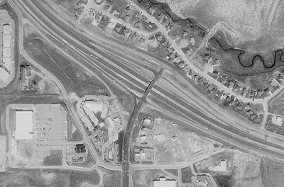 |
| Google Earth, 1993. |
 |
| Google Earth, 2002. |
That bridge, by the way, is one of a few of this age across the state that is decorated with Olympic related pictograms and mountains. Similar designs can be found on the SR 154 bridge over I-15 in Draper as well as the South Weber Drive bridge over US 89 in, well, South Weber.
Also due for an upgrade was the intersection of Marsac and Deer Valley Drive just outside of downtown Park City. That intersection had come into being with the 1985 downtown bypass and started out as a rather messy 3-way intersection. In conjunction with the construction of a transit center on Swede Alley, the Marsac/Deer Valley intersection was converted to a roundabout:
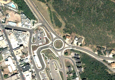 |
| Google Earth, 2002. |
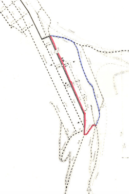
But that wasn't enough for the Olympics. The bobsleigh, skeleton, luge, ski jumping, and Nordic combined events were slated to be held at the new Utah Olympic Park, located southwest of Kimball Junction. The Park was constructed by the state of Utah, and it was agreed that the main access road to the park, named Sport Park Road, should also be built and maintained by the state through the Olympics. So in June 1999, the state and Summit County signed a cooperative agreement regarding this road, which would connect the park's north entrance to SR 224. In an interesting twist, the agreement stipulated that on September 30, 2002 (after the Olympics), the road would be transferred to Summit County - thus creating what I believe is the only temporary state highway in Utah history.
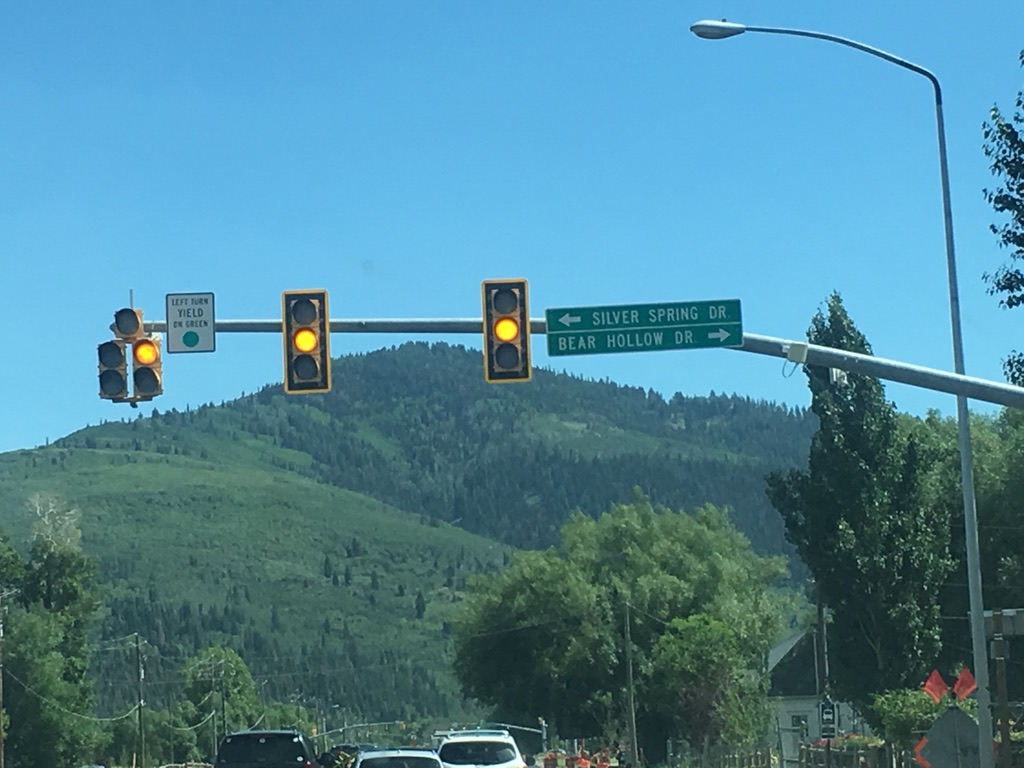
The state also constructed Bear Hollow Drive, which is a back entrance to the Olympic Park that probably was only used for service and maintenance type activities. It was apparently originally supposed to be maintained by Summit County, but by 2001, it had been determined that more upgrades were necessary and that UDOT should be responsible for the road until the Olympics were over. So in June 2001, the Utah Transportation Commission created SR 223, covering Sport Park Road and Bear Hollow Drive. It can be seen on the map below:
 |
| UDOT, 2001. |
What's interesting is it appears this was never fully drivable as a continuous public road. There is still a gate at the "locked gate" label above, and the road actually crosses under the bobsled track at the second hairpin (right above the last "n" in "Engineer Station"). So the entire segment between the main parking lot and that locked gate has probably always been a service-only road. Nevertheless, it was all part of SR 223 through the Olympics, though more likely than not this designation was never signed before it lapsed in September 2002.
The Olympics were quite good at putting Salt Lake City on the map, so to speak, and increasing its national and even international profile. As a result, high-end real estate development increased dramatically, along with expansion at the Deer Valley ski resort. In 1998, Deer Valley had opened a new lodge at the head of Empire Canyon (unsurprisingly called Empire Canyon Lodge). However, this lodge was inaccessible by road during winter months, as the road to the lodge intersected SR 224 above its seasonal closure point. And it's not like they could have just moved the seasonal closure further up the mountain - SR 224 actually crossed six ski runs, which had been the case since 1990 when Deer Valley first expanded onto Flagstaff Mountain. In the imagery below, the lodge is at bottom left. SR 224 can be seen entering the frame at the bottom, then curving to the right to cross the ski runs and the Northside Express lift:
 |
| Google Earth, 2002. |
That wasn't a huge deal at first - there's plenty of ski resorts with lodges or restaurants with no road access from the bottom. The issue is that Deer Valley and United Park City Mines (which at this point was no longer a mining company but a real estate developer, despite its name) wanted to develop the Empire area further with restaurants and lodging. Can't exactly have a high-end hotel if you can't drive to it. So to solve this issue, UDOT and United Park City Mines (UPCM) came to an agreement in the early 2000s to move the seasonal closure point about two miles to the south, up the mountain, as long as UPCM would be responsible for plowing the road above the old closure point at the Ontario Mine.
Shortly thereafter, UPCM built a new road from SR 224 to the Empire Lodge that went north around the base of the Northside Express lift. In November 2002, the transportation commission signed a resolution transferring this new road as well as the original driveway from 224 to the lodge to UDOT, and SR 224 was moved onto these roads.
 |
| UDOT, 2002. |
The old alignment of 224 across the ski runs was completely obliterated as a road - but it can still be easily identified by its lack of trees. And in fact, it can even be skied in winter on the ski resort! There obviously aren't any signs for it, but it's a linear tree clearing crossing the mountain that doesn't exist for an immediately obvious reason (like a ski lift or a power line).
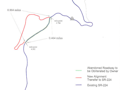
A year later, another major realignment occurred in this same area, immediately to the northeast. Again, a new alignment was built by Talisker Corporation (which had just purchased UPCM) around the base of the proposed Silver Strike Express lift, and then transferred to UDOT in exchange for the old alignment. The map associated with these changes is shown below:
 |
| UDOT, 2003. |
Unlike the Northside alignment, the Silver Strike alignment was not done specifically to increase connectivity - it was entirely to allow for more development. And unlike the old Northside alignment, which is still hikeable and skiable, nearly all traces of the old Silver Strike alignment are gone and have been built directly over by new condos and hotels. The exception is a couple short sections of the residential Silver Strike Trail and Empire Club Drive, which were in part built right on top of old state highway alignments.
Both realignments, however, were built to a better standard than the state highway that was there before. They might be the only examples of privately-built state routes in Utah, and they feel a lot more like a private subdivision road than a state highway. Nonetheless, with these realignments and some more snow plowing in winter, there was now a road to Empire Lodge in good enough condition to be open year-round. The 224 winter closure gate was moved to a spot just above (south of) the spot where the original driveway to Empire intersected 224. It remains there to this day.
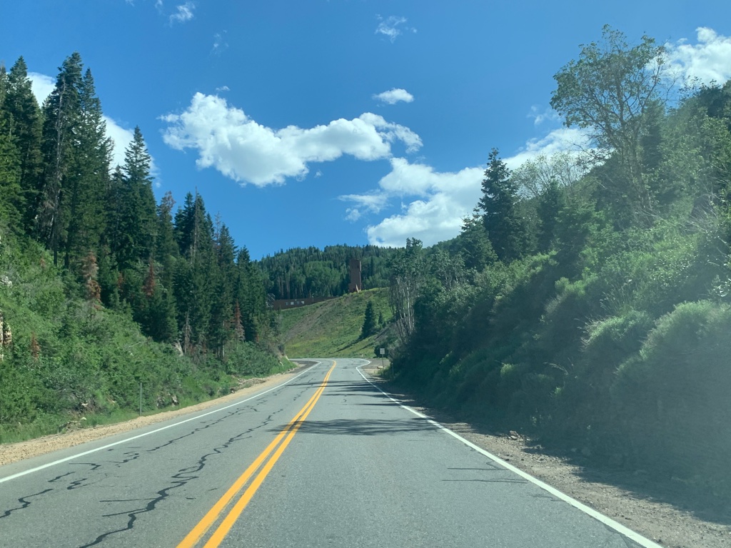
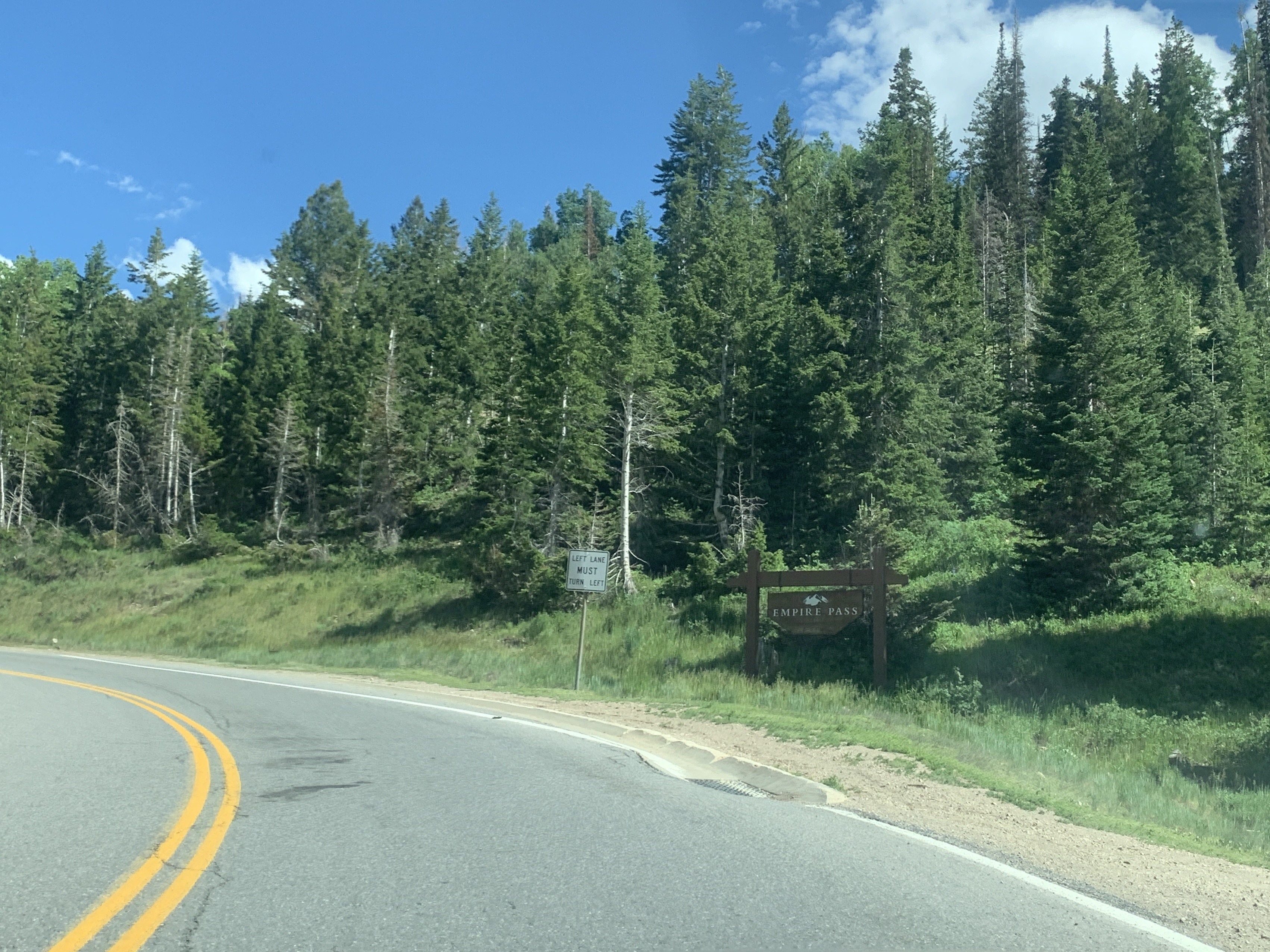
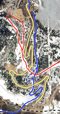
That is the current state of SR 224. While there aren't any more changes in the immediate future, there has been plenty of discussion. Back in the mid-2000s, there were serious discussions to eliminate some or all of SR 224 in the mountains south of Park City, or perhaps even through Park City itself. Those records are in some Utah Transportation Commission meeting minutes, which seem to have disappeared from UDOT's website when they redesigned it a year or two back. More recently, substantial residential development has occurred even higher and closer to Empire Pass, above Empire Lodge. This again posed an issue for year-round access, as the current SR 224 still crosses the Bandana ski run and the Ruby Express chair lift and has done so since those were built in 1998. So the developer in this case built Twisted Branch Road, which leaves 224 just before its seasonal closure point and is essentially a second road up to the Empire Pass vicinity.
The map below illustrates the current state of affairs in this area. In blue is SR 224 with orange markings at its seasonal closure point, yellow is Twisted Branch Road, and red is the Bandana and Lucky Jack ski runs at Deer Valley. The dotted black line at the bottom is the ridge crest and also the Summit-Wasatch county line; 224 crosses it at Empire Pass.
 |
| Google Earth, 2023. |
As mentioned above, SR 224 crosses the Bandana run at grade. However, there is an overpass constructed on the ski run just to the west of 224, which allows snowmobiles, cross country skiers, and other people using the closed SR 224 to cross under the ski run without trespassing onto Deer Valley property. Another overpass just to the west carries the ski run over Twisted Branch Road, which itself has an overpass over SR 224 just to the south.
Twisted Branch is kept open year-round, which is possible since its crossings of both the Bandana run and winter-closed SR 224 are grade separated. In terms of road quality, it's also a better and safer road than 224 is through this area. 224 has no shoulders and several steep drop-offs of 150-200 feet and is not wide enough for two cars to pass in several places. UDOT currently has no projects to improve 224, which would be hard to pull off given terrain and geometrical considerations. Twisted Branch is not subject to these issues. But here's the catch: Twisted Branch is not open to the public and never has been. It is owned by REDUS, a development subsidiary of Wells Fargo, which keeps it gated off and inaccessible to anybody beyond residents of the Red Cloud and Brighton Estates neighborhoods and construction/maintenance vehicles.
I'm not really sure of the details, so I won't go in too deep, but there is a large contingent that wants 224 moved onto Twisted Branch, in the same way as it was moved onto privately-constructed roads further north, simply for safety reasons. So far, REDUS does not want to play ball, but apparently might be able to be forced into it by the Park City council? There's also residents of Brighton Estates in Wasatch County, who are allowed to use Twisted Branch to get close to their homes in winter before snowmobiling the rest of the way there (since 224 is closed in winter). They don't want any year-round public road access to the top of Empire Pass, because there are plenty of winter recreationalists who cross-country ski, snowshoe, snowmobile, etc. on the closed part of 224 in winter, who typically park at the existing 224 seasonal closure. If Twisted Branch were to become 224 and open year-round, these people would likely park at the top of Twisted Branch, just below the Wasatch County line, which Brighton Estates residents need kept clear. There's been talk of transit being operated on Twisted Branch for these residents, which REDUS likely would have allowed, but the residents worried that the transit would not be available at reliable intervals or all times of day/night when they might need it. There is also the issue of a construction gate allowing gravel road access from the top of Twisted Branch to Empire Pass, allowing those with access to Twisted Branch to bypass the dangerous part of 224 despite the fact that the road was never supposed to allow those with the right to use it access to Wasatch County. Which in itself is also a compounding factor - because Brighton Estates is in Wasatch County, it's outside of the jurisdictions of Summit County and Park City where Twisted Branch is.
Bottom line: this is a mess of different disputes, jurisdictions, and ownerships that probably is not sustainable long term. Summer traffic on this upper part of 224 has increased dramatically since the late 2010s, with Wasatch County paving the connections to Midway and Guardsman Pass (former SR 224 and 190 respectively) and especially after Park City purchased and expanded the Bonanza Flat Conservation Area in Wasatch County with its miles of trails and other recreational opportunities. And because it is immediately east of Guardsman Pass, it forms a key part of one of only five summer paved crossings of the Wasatch crest. As traffic increases on the parallel major routes, the amount of people using 224 as a scenic alternative to I-80 to Park City has also increased.
After summer 2020, it looked like a transfer where REDUS and UDOT would swap existing 224 for Twisted Branch, in the same way as had been done below Empire Lodge two decades earlier, might be coming soon. That year, at least two major commercial vehicle crashes occurred on upper 224, and when a wildfire in Parleys Canyon closed I-80 for several days, there was a huge increase in traffic simply connecting from Park City to Salt Lake. Another major dump truck rollover occurred in November 2021.
In March 2022, the Park City Planning Commission made a unanimous recommendation that REDUS petition UDOT to go through with the road swap, and that the Park City Council take action to address this issue. Neither of those things have happened yet. But it seems that at some point in the medium term, 224 will probably be realigned onto Twisted Branch Road all the way to Empire Pass, with that construction gate at the top paved and made a permanent part of the road. Whatever final arrangement is done, it sounds like the main goals of any potential realignment would involve keeping the winter closure to vehicle access above Empire Lodge, with an exception made for Brighton Estates residents and city maintenance vehicles.
I don't have a whole lot of photos from 113 or 222...