Let's head back west of the Wasatch for this post and focus on the far southern end of the main Wasatch Front corridor and a bit beyond. For this post, I'll discuss the history of the routes passing through the Juab Valley region, from Gunnison and Mills Junction up through Levan, Nephi, and Mona and on to Santaquin.
(By the way, you may have heard that "Levan" is named because it is "navel" spelled backwards, since it's in about the middle of Utah. While interesting, this is probably a folk etymology - a number of more plausible origin theories are out there.)
 |
| SR 78, which is old US 91, heading west (south) from Levan with the West Hills in the background. The farms and ranches seen here are pretty typical for this area. |
The north-south highways through this area date back to the earliest days of the state highway system. The road from Millard County up by Yuba Dam and through Levan, Nephi, Mona, and Santaquin became a state highway in 1910. However, a 1916 State Road Commission report stated that the road from Levan north to Utah County was added to the state highway system in December 1915 - this may have been related to an improvement or maybe a realignment project. The same report states that in February 1916, the road from Levan south to the Sanpete County line became a state highway, connecting with a road running north from Gunnison through Fayette that had been added to the state system a year before. Federal aid to state roads began in 1917, and over the next two years a federal-aid project improved the road from Levan southwest to Millard County.
In 1919, the state legislature trimmed down the size of the state highway system to a short list of defined corridors plus any federal-aid projects. The Millard County-Levan-Nephi-Santaquin road, by now also part of the Arrowhead Trail, was defined in section A of the 1919 law. The Gunnison-Levan road, however, was not included in any of the corridors, and was dropped from the state system accordingly.
At some point in the early 1920s, the State Road Commission assigned numbers to the most important "trunk line" state highways, and the Arrowhead Trail state route became SR 1. The following map was made in 1923, after the trunk lines had first been numbered:
 |
| USRC, 1923. |
In 1925, the legislature added the Gunnison-Levan road back to the state highway system, in a spur route added to section D of the state law (this section primarily designated the road from Arizona to Nephi via Richfield, Gunnison, and Manti). However, as it was not a major trunk line, it did not receive a number.
The U.S. Highway system was proposed in 1925 and approved in 1926; it designated essentially all of SR 1 in Utah as US 91. The next year, the state legislature overhauled the state highway system - they got rid of numbered all of its previously unnumbered state highways: the Gunnison-Levan road became SR 28 at this time.
The original US 91 and SR 1 before it probably followed Old Yuba Dam Road by Yuba Dam (that's also labeled "Old U.S. 90" on maps, which is obviously wrong and was supposed to be 91). It may have followed the road labeled on Google as "First 91 Rd" for a segment south of the dam, though if it did it had been realigned by 1940. 91 went north from the dam and then turned northeast on Yuba Dam Road (labeled "Old State Rte 78" sometimes, which is also wrong) and on by the rail siding of Juab, turning east and entering Levan on 100 North. From there, it curved north and exited the town on 100 East, then continued on north and passed through Nephi and Mona along Main Street and The Mona Road. It then crossed into Utah County and entered Santaquin on 200 West, turning east on Main Street and then continuing northeast on Orchard Road towards Spanish Fork. Original SR 28 began on Main Street in Gunnison, passed through Fayette on Main Street, and entered Levan on none other than Main Street (!) and ended at 100 North at its junction with US 91.
Those original routes, as they appeared on the 1929 state map:
 |
| USRC, 1929. |
So by this time, as had been the case back in 1925, US 91 was paved down to Nephi, and 91 and 28 south of Nephi were a mixture of gravel and improved dirt. US 91 was fully paved south from Nephi through Scipio by 1932. 28 was completely paved by 1937, far earlier than most state roads, which was a statement to its importance - it is perhaps the most important state road that never got a US highway designation.
Looking at that 1929 map above, it does look as though it would have made for quite a long trek if you wanted to go from, say, Scipio to Fayette using state roads. Perhaps this is why, in 1935, the state legislature defined SR 160:
Route 160. From route 1 near Juab easterly to junction with route 28.
"Near Juab" would suggest an east-west alignment along something like Powell Lane, which is two miles south of Levan. But let's look at a map. The first map I'm aware of this route appearing on is the official state map from 1940. A screenshot from that is shown below:
 |
| USRC, 1940. |
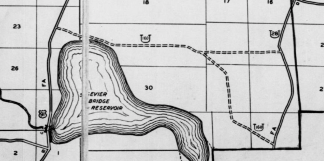
So right away, that rules out anything near Powell Lane, and "Juab" wasn't really a good descriptor of the western terminus of the route. This was far closer to the Sevier Bridge Reservoir (the official name for Yuba Lake). But exactly where? Let's look at the 1940 census enumeration district maps:
 |
| US Census, 1940. |
That pretty clearly puts most of 160 along Old Botham Road, which even today is more or less the last through road between the I-15 corridor and SR 28. But per this map, not all of Old Botham was 160. Even though Old Botham Road was intact as a full connection by then, it appears 160 did not follow it east of the junction with Yuba East Shore Road. Rather, it went southeast, south, and southeast again, ending at SR 28 just north of the Sanpete County line.
That southeastward road appears to not exist in any form today. The lack of any sort of scar on satellite imagery where this supposed alignment of 160 ran is interesting - usually even with abandoned roads there is some evidence they once existed, unless it got flooded by a reservoir (which is not the case here). As a result, I do wonder whether 160 simply followed Old Botham all the way across to 28 and the census map is wrong.
At any rate, several years later, US 91 was moved to a new alignment between the junction with the road west to Mills (unsurprisingly known as Mills Junction) and just north of Scipio. The bridge carrying it over the Sevier River was built in 1950, suggesting it was complete around then. (That bridge still stands, by the way, and is used by the I-15 frontage road.) The new 91 alignment was about two miles west of the old one, and bypassed Yuba Lake entirely where the old one had gone over the dam itself.
The new 91 alignment does raise the question of what happened to the west end of SR 160. Was it extended to connect with the new 91 alignment? Let's take a peek at a USGS map from the time:
 |
| USGS (Scipio North), 1952. |
Answer to that question appears to be no. 160 was never a route the state particularly cared much for - even by the 1950s, it was still an unimproved dirt road - and the realignment of 91 was probably the final nail in the coffin. The legislature deleted the route in 1953.
At around the same time as all this, US 91 was moved to a new alignment bypassing Santaquin. This was probably built around 1950, at more or less the same time as the Yuba bypass. It appeared on the 1951 USGS map of the area:
 |
| USGS (Santaquin), 1951. |
The old alignment along Main Street and Orchard Road remained on the state highway system as a part of US 6 (and SR 26 was extended east slightly to the new junction with US 91). But what about old 91 south of the town? It wasn't shown as anything on that map, nor on any other map I've come across...but 1959 state law included a SR 26A:
Route 26-A. From Santaquin on route 26 southerly to route 1.
That almost certainly was the old 91 alignment on 200 West and The Mona Road. Because it was a suffixed route, not much is known of its history, and there's a chance it may not have even been signed. I would guess it was probably created by the legislature in 1953, based on the huge amount of changes to the state highway system that happened that year.
Meanwhile, two small realignments were made on SR 28 in Sanpete County about a decade later. The first was in 1966 immediately east of Yuba Lake...
 |
| USDH, 1966. |
...and the second slightly further south in 1972, which moved 28 to an eastern bypass of Fayette:
 |
| USDH, 1972. |
That shift made Fayette one of a small handful of incorporated places in Utah without a state highway, as the new alignment fully bypassed Fayette's town limits. This is still the case today.
However, the bigger changes to the local highways during this time happened with the coming of the interstates. In 1962, a lot of state routes were changed around so that SRs 1 through 5 would be used as legislative designations for the interstates proposed to run through Utah. At the time, that changed nothing in the Juab County vicinity, since SR 1 was the designation for both US 91 and its replacement I-15, and the interstate would not be built in this area for some time.
Based on bridge data, I-15 was completed from the Utah-Juab County line north through Santaquin around 1967, and this segment was built either directly over or immediately adjacent to US 91. Since no interchange was built on I-15 where 26A had junctioned 91 south of Santaquin, that was probably the end of SR 26A. The west-side frontage road to I-15 (old 91) from 26A to a point about 2.5 miles south of the Juab County line was probably turned over to county jurisdiction at this time.
The next year, a whole bunch of changes were made in and south of Nephi with the proposed construction of I-15. In January 1968, the State Road Commission approved a resolution to move SR 1 onto the proposed route of I-15 between Juab (the bend in US 91 at the railroad directly west of Levan) and a proposed interchange with existing US 91 just north of Nephi. The planned interstate included interchanges at those endpoints and also at Experiment Station Road north of Levan and Elevator Road south of Nephi.
The plan was that US 91 between Experiment Station Rd and Elevator Rd would be removed from the state highway system. A new SR 41 was created for Main Street through Nephi, presumably also connecting west on Elevator Road to the I-15 south Nephi interchange. The remainder of old 91 between Levan and Experiment Station would become a northward extension of SR 28, while the east-west portion from Juab to Levan was designated as a new SR 163. That was all illustrated on this 1968 planning map:
 |
| USDH, 1968. |
Obviously, these weren't to take effect until I-15 was built, which wouldn't be for some time... and none of this would have been signed, as these surface routes were all still US 91. Take a close look at that map, though, and you might notice that this wasn't where I-15 was built. We'll get to that in a minute.
In 1969, SR 28 was extended south as an unsigned designation for US 89 from Gunnison south to Salina. This was because the previous designation for that part of 89, SR 11, had to be truncated to the south to avoid an overlap on I-70 (SR 4). The southern terminus was defined as the I-70 interchange south of Salina...but functionally it was in central Salina until 1976, when that interchange on I-70 opened. Also, US 89 and underlying SR 28 originally ran through the center of Redmond. Those routes were moved to the current bypass in 1970, but unlike the Fayette bypass further north, the old route through Redmond remained on the state system as SR 256. Again, other than the Redmond bypass, none of these changes would have been signed.
Also in 1969, the State Road Commission officially moved the remainder of SR 1 between Nephi and Utah County to the proposed I-15 bypass. The legislative underlay for the segment of US 91 between those two points became a northward extension of SR 41, which had just been created to serve essentially as a Nephi business loop. At this point, all remaining segments of surface US 91 in Juab County were probably also signed as Temporary I-15.
In 1971, the commission approved a resolution to transfer all of US 91/unsigned SR 41 through Mona and north all the way to the Utah County line to Mona city and Juab County. In exchange, SR 54 was created to connect Mona to an interchange that would be built on I-15. The map attached to one of those agreements was shown below:
 |
| USDH, 1975. |
This segment of interstate and associated SR 54 connector opened in 1974 or 1975. The new interstate extended south to a point roughly halfway between Mona and Nephi, where a connector road was built to link the new interstate and old 91:
 |
| USGS (Mona), 1983. |
It's closed to traffic now, but that connector road is still visible today.
In 1977, Utah executed a large renumbering that affected all state routes that shared a number with an interstate or US Highway, as well as those routes that served as an unsigned state route underlay for an interstate or US Highway. That affected two routes in this area. The unsigned SR 28 overlap with US 89 was eliminated, leaving the south end of 28 at Gunnison (where it has remained since). And SR 163 was renumbered to SR 78, due to the existence of US 163 in southeastern Utah.
 |
| USGS (Nephi), 1981. |
The 1981 map above shows the new SR 78 designation, extending from Temporary I-15 near Sharp east to Levan. (Yeah, I know there's an I-15 shield there, but that was still the original two lane US 91.) I-15 still was not open through southern Juab County, and because of this, the planned transfer of old US 91 to local jurisdiction between SR 28 and SR 41 had not happened yet. So for the time being, 28 and 41 simply ended at each other at some point just south of Nephi.
That I-15 segment would not open for several more years. The section of old 91 between Scipio and Mona became known as the "Nephi Death Strip" or "Levan Death Strip", as it was the last two-lane section that I-15 had not replaced from at least the Arizona line through the Wasatch Front. By 1983, it was finally under construction, as seen in the state map from that year:
 |
| UDOT, 1983. |
Notice there were some pretty substantial differences between the proposal from the 1968 map and the road that was built. Most notably, it was built significantly farther west between Mills and Nephi, and it ended up bypassing Nephi to the east rather than the west. The segment would be completed by 1986, and was the second to last section of I-15 to open in Utah (the last one was from Tremonton to the Idaho border). Fun fact: this was late enough that it was after UDOT assigned exit numbers to all of its interstates. Unlike many eastern states which use or initially used sequential exit numbering, Utah used mileage-based numbering from the start. That meant they had to guess how long this Nephi segment would be in order to number all I-15 exits to the north, including through the heavily populated Wasatch Front metropolitan areas. Not an easy task when you don't even know the route of your highway yet. As it turned out, UDOT's guess was too high by about 3 miles, and so once the full interstate was mileposted accordingly, all of the exit numbers north of Nephi were between 2 and 4 higher than their corresponding milepost. They were all renumbered in 2005, mostly with patches that were stuck over the old numbers. Most of those signs have since been replaced, but a few do still stand. So if you see an exit number patch in Salt Lake today, that is why it's there, and it means the sign is older than 2005.
But back to Nephi's routes in the 80s. The western alignment between Mills and Nephi meant that old 91 would remain a distinct road between Mills and the eastward bend towards Levan, instead of being swallowed up by the interstate. The existing definition for SR 78 only included the east-west segment directly west of Levan, assuming it would end at the bend near Sharp. As a result, the 1986 Utah Transportation Commission signed a resolution extending SR 78 southwest along old 91 to the Mills Junction interchange, which was approved by the legislature the following year.
The other substantial change was that in the original plan, when I-15 was set to bypass Nephi to the west, there would be two interchanges between Nephi and Levan, with short connector roads to old US 91 a short distance east. There would also be an interchange north of Nephi where 15 would cross old 91. Instead, with the I-15 alignment east of Nephi, there wound up being only one interchange between Levan and Nephi, where 15 directly crossed old 91, and a new connector road had to be built from old 91 to the north Nephi interchange on I-15. Here is how that ended up looking after it opened in 1986:
 |
| USGS (Nephi), 2001. |
SR 41 was shifted over to the new connector just north of Nephi and ended right at I-15; the segment of 41 on Mona Road between that connector and the previously existing I-15 connector near Mona was given to Juab County at that time. As the map shows, since there ended up being only one south Nephi interchange, none of old 91 was ever decommissioned south of Nephi. So what ended up happening was 28 and 41 came to end at each other at the south Nephi interchange (exit 222). Both were old 91, with 41 on the Nephi business loop and 28 on the longer corridor towards Levan. And speaking of business loop, the Business Loop I-15 designation was also applied to SR 41 as soon as the interstate opened.
Of course, two routes ending at each other is silly in a case like this where they're clearly the same road. Which is why in 2006, SR 28 was extended to the north Nephi interchange, absorbing all of SR 41.
Route Photos
SR 28
 |
| SR 28 begins with a four-line mileage sign. The bottom line is Salt Lake City, consistent with 28's role as a more important interregional corridor. |
 |
| Reassurance shield with the San Pitch Mountains at right. They rise from the southernmost segment of the Wasatch fault zone, potentially overdue for a large earthquake. |
 |
| After crossing into Juab County, we'll enter Levan, where we will junction SR 78. |
 |
| Turn left for access to I-15 south; stay right for I-15 north. |
 |
| SR 78 begins to the left. Note the I-15 control cities. The junction is laid out this way because originally, the cross street was US 91. |
 |
| Reassurance shield after we turn onto old US 91 |
 |
| Mileage sign leaving Levan, again with longer distance control cities. |
 |
| I-15 is 10 miles away. Levan suffered from being bypassed by the interstate a lot more than other US 91 towns. |
 |
| 10 miles later, after crossing the drainage divide between the Sevier Lake and Great Salt Lake basins, we'll reach Nephi. Stay straight for the hospital and city center, turn right for I-15 north to Salt Lake. |
 |
| A pair of interstate shields with state name. |
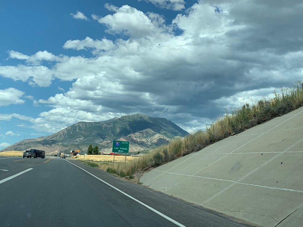 |
| A lot of the newer generation of signage on this road uses Las Vegas as the southbound control rather than Cedar City, which I think is unfortunate. Perhaps they could use St George as a compromise now that it has a metropolitan area of almost 200,000. |
 |
| SR 28 reassurance after the I-15 interchange, as we follow the historic route of US 91 through Nephi. This is also Business Loop I-15, but that's not signed from here. |
 |
| In central Nephi, we will junction SR 132. |
 |
| I-15 can be accessed either by staying straight on 28 or turning right on 132. Turns out it's about the same time. |
 |
| SR 132 goes to Delta and Ephraim. In the 1930s, US 189 began to the right. |
 |
| No reassurance or anything else of note before we leave Nephi. As we leave the town, we can turn around and see a rare instance of BL-15 co-signed with SR 28. Many interstate business loops in Utah tend to only be signed from the freeway. |
 |
| 28 has another interchange with I-15 north of Nephi. The northbound control city there is "Provo / Salt Lake" which I think is the only control usage of Provo on northbound I-15. |
 |
| SR 28 ends at the frontage road past the interstate, at the base of 11928-foot Mount Nebo. |
SR 78
 |
| SR 78 begins in Levan on Center Street, which is old US 91. |
 |
| We'll reach I-15, which replaced 91, in 9 miles. |
 |
| Now well outside of Levan, we'll turn to the southwest to parallel the Union Pacific Railroad at Elevator Road. Originally, 78 was supposed to end at I-15 right about here, but the interstate ended up being built further west. |
 |
| SR 78 rides along the embankment dam that holds back Chicken Creek Reservoir to the left. Now, "reservoir" is a generous word considering that there is rarely ever any water in it. |
 |
| From there, we'll follow Chicken Creek around the bend to Mills Junction, where we'll reach I-15. |
 |
| The typical long-distance control cities are used here. |
 |
| Stay straight for I-15 south, turn right for I-15 north. |
 |
| Turn left for I-15 south. |
 |
| If you missed the last three signs, this one is for you. |
 |
| There are no services on the west side of I-15 - but interestingly enough, 78 doesn't quite end here. It keeps going for a bit longer. |
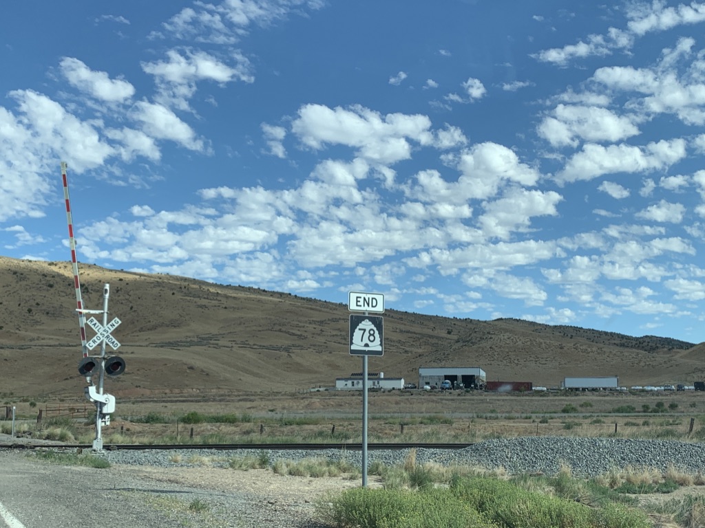 |
| The real end of SR 78, just short of the railroad tracks. |


