It's been a while since I've posted something here, but I've finally written up a post about two important north-south highways in the Salt Lake Valley - SR 71 and SR 111. It might seem a little confusing at first that I'm including both of them in one post, as they seem to have nothing in common other than that they're two of the valley's many north-south routes - but it turns out that over the years there's been quite a bit of overlap between them.
Both routes were created by the state legislature in 1931, and both ran through Draper. They were initially defined as follows:
(71) From junction with route 4 at Ninth East in Salt Lake, southerly to Draper south easterly via corner canyon and Alpine to junction with route 1 American Fork.
(111) From Draper westerly to Riverton.
A good bit of that definition of SR 71 looks fairly similar to what you'd find on a map today. At the time, SR 4 (the legislative designation for US 40) was routed on 2100 South in eastern Salt Lake City, so the original north end of 71 was the intersection of 9th East and 21st South. From there it proceeded south through the valley along 900 East to the Fort Union area, where it curved west into 700 East at about 77th South. Often times, curves like this were originally a series of right angles that later got smoothed out (we'll see one of those in a minute), but this one from 9th to 7th East in Fort Union looks to have been around from the beginning, especially if the 1940 census map is any indication:
.
 |
| US Census, 1940. |
From there, 71 continued down to "Draper" - which appears to refer to what is now the intersection of 700 East and 12300 South. A detailed reader might notice that there is no road connecting Draper and Alpine via Corner Canyon - much of that was a proposed road that was never built. But based on those 1940 census maps, 71 was probably intended to get there from Draper by going east on 12300 South, south on 970 East and Fort Street, east on 13200 South, and then southeast probably around what's now Highland into Corner Canyon. However, the southernmost portion of the route from Alpine to American Fork did exist, along Alpine's Main Street, 5300 West, Alpine Highway, and American Fork's 200 East, 300 North, and 100 East to Main Street (US 50/91).
If any of these roads south of Draper were ever signed as SR 71, it was only for a very brief period. By 1935, the legislature apparently realized that no state highway would ever be built through Corner Canyon: the segment from Draper to Alpine was deleted, and the Alpine-American Fork highway was split off as SR 74 (which I'll talk more about in a future post). That left 71 as a north-south route along 9th and 7th East from Draper to Salt Lake City.
SR 111, on the other hand, looks nothing like the highway that bears that number today (though they are the same route). From Draper, 111 ran west on 12300 South to Riverton - the junction of Redwood Rd and 12600 South. Much of that route is pretty clear from a modern map... but today's connection between 123rd and 126th South across the Jordan River did not exist. Back then, 12300 South continued more or less due west across the Jordan River before curving into 12400 South. 111 then used 1300 West to make the two-block connection between 124th and 126th South before continuing west to Riverton, where it ended at its junction with SR 68.
Two years later, the legislature created SR 159:
(159) From Junction with route No. 4 south of Magna southerly along foothills to Lark and then easterly via Fort Harriman to Riverton.
Interesting spelling of what's now known as "Herriman". If we reverse the description to a more modern south-to-north direction, SR 159 began at SR 68 at Riverton, directly across from the west end of SR 111. 159 headed west to Herriman by way of 12600 South and Herriman Main Street. From there, it continued west to the ghost town of Lark, then north through the ghost town of Bacchus to Magna. 159 entered Magna along 8400 West and ended at the intersection with 3500 South, where it junctioned US 50 (legally SR 4). Much of that route is pretty self-explanatory from a modern map, except it should be noted that Herriman Main St used to continue directly into 12600 South on the east end (today a turn is required). In addition, the original alignment of Herriman Main between 126th South and about 56th West is no longer even a road due to a major realignment that occurred with new development in the area in the mid-2000s.
But exactly how did it get from Herriman to Lark? The obvious answer would be the Herriman Highway - but examination of historic maps suggests this may not have been the case. Although SR 159 was created in 1933, the first time it was explicitly shown on Utah's official map was the 1938 edition, shown below:
 |
| USRC/Gousha, 1938. |
So from Herriman, the original SR 159 probably went north on 6000 West (now also Mustang Trail Way) to 11800 South, where it turned west towards Lark. It appears Lark was initially served by a spur of 159, while the mainline continued north. This map makes it look like 159 had a concurrency with or maybe a gap at 48 from the modern Bacchus/Old Bingham Highway junction (the point labeled "Dalton" on that map) west to around Copperton, but I'm inclined to say that's bad cartography as neither USGS nor census district maps even show any sort of north-south road west of the Bacchus Highway. So I'm pretty sure that from the beginning SR 159 followed the modern Bacchus Highway pretty closely between Lark and Magna, passing through Bacchus. A few minor straightening realignments have probably occurred through the years between the Bingham Highways and Magna, but it is largely the same corridor.
(You might notice many of these town names don't exist today. Lark was actually a fairly substantial mining town with a population of several hundred in the first half of the 20th century. By the 1970s, the mines closed, and the townsite has now been swallowed up by dumping from the large Bingham Canyon copper mine not far to the west. Most of Lark's population moved to nearby Copperton. Bacchus hosted an explosives plant in the early 1900s, but was gone by the middle of the century. Dalton looks to be the name for a now completely-abandoned railroad junction where a line to Lark split off from the line to Copperton.)
By 1939, any 159 alignment via 11800 South had been replaced by the Herriman Highway. That was first shown on the 1940 edition of the state highway map:
 |
| USRC, 1939. |
That map doesn't even show SR 111, which since 1935 had been in a rather strange position where it wasn't really necessary as a separate designation because shared its endpoint with that of another route on both ends - 71 and 111 ended at each other in Draper, and 111 and 159 ended at the same point on SR 68 in Riverton. However, that setup lasted only 10 years. In 1945, SR 159 was decommissioned and absorbed into SR 111, which now extended from SR 71 in Draper through Riverton, Herriman, and Lark, then northward to US 50 southeast of Magna.
 |
| Shell (Utah), 1950. |
In 1957, the northernmost several miles of SR 71 were moved west two blocks to 700 East, and the north end was extended to SR 181 at South Temple. This was presumably done in conjunction with the construction of the Cottonwood Diagonal (now Van Winkle Expressway)... however that was not built for several years. The first edition of the state highway map that explicitly showed the extension was the 1961 Salt Lake inset, shown below:
 |
| USRC/Rand McNally (Central Utah), 1961. |
So the initial northward extension appears to have involved a two-block concurrency with (or gap at) US 40/SR 4 on 2100 South to shift from 9th to 7th East. But this didn't last long - Van Winkle had been built by 1962, and upon completion of that road, 71 was moved to use the northernmost piece of it, tying directly into 700 East all the way down at 45th South. That was shown on that year's Salt Lake inset map.
 |
| USRC/Wheelwright (Central Utah), 1962. |
The 1957 legislative descriptions also had a rather odd change to the endpoints of 71 and 111. The routes still ended at each other, but rather than this occurring at Draper, it occurred at "7700 South" ... which is not a road, but it is where 700 East curves into 900 East as you're going north. More specifically, the south end of 71 was defined as "7700 South", and the north end of 111 was defined as "route 71". I'm skeptical whether this change was ever signed, because it never appeared on any map I'm aware of... and even if it was signed, it was reverted in 1959, returning the route junction to Draper.
The next change to SR 111 came in 1962, but at the other end up in Magna. 1962 was the year of a significant renumbering effort where route numbers 1 through 5 were reserved as legislative designations for Utah's new interstate corridors. While this wouldn't have affected 111 directly, recall that its north end was at SR 4 (which by now no longer carried a US highway - 50 had been rerouted entirely out of the Salt Lake metro, and the replacement Alternate 50 ran along 21st/24th South). So most of SR 4 along 3500 South in the west valley became an extension of SR 171.
I bring this up because the new SR 171 definition terminated at SR 111 south of the Magna city center, and no number was designated to connect either of those routes to Alt 40-50/SR 201 - so per the 1962 descriptions, as legally defined, 111 and 171 ended at each other. This seems like a mistake on the legislature's part, and the next year, it was corrected to extend 111 north to Alt 50/201. But exactly how did it get there? Looking at a modern map, you'd assume it would have just followed 8400 West north to 201. But historic maps tell a different story:
 |
| Gousha (Salt Lake City-Ogden), 1964. |
That map had 111 going north on 8400 West, but then west on Magna Main Street and north on 9180 West - i.e. along old SR 4/US 50 through Magna. However, it is also worth noting that the connection on 8400 West between Magna Main and 201 was brand new, opening only around 1960. So was this just a minor cartography error that occurred because the mapmakers didn't know that road existed yet? Let's look at the official state map's Salt Lake City inset from that same year:
 |
| USDH/Rand McNally (Central Utah), 1964. |
The state map is indeed aware of the existence of the 8400 West connection directly to 201 (in fact, that had first appeared on the 1962 edition). At first, it seems unclear where they have 111 going in Magna... but take a closer look at those mileage numbers. Those are only provided for reference along state highways, and they are present on the road through downtown Magna... suggesting 111 did in fact go that way. Evidently the old road through Magna was not turned over to local jurisdiction in the 1962 renumbering.
In 1965, the legal description of the north end was changed from "Route 201 north of Magna" to "Route 201 northeast of Magna", which would have moved the north end to 8400 West and 201 (where it still remains). It is worth noting that the state map did not change those mileage numbers on any subsequent state map all the way through the 1972 edition, when the Salt Lake inset map stopped covering this part of the valley - though this was probably such a minor detail it wasn't really worth putting in the effort to change.
SR 111 received two more realignments a few years after that, but these were on the southern portion. The first was in Riverton, and it came about because the direct connection between 126th South in Riverton and 123rd South in Draper had finally been constructed. That was built in 1967, and the state road commission approved moving 111 onto the new alignment the next year:
 |
| USDH, 1968. |
The other one was down in Lark. By now, Lark had evidently decayed enough that it was no longer worth having a highway go right through it, and a bypass was built that also removed the segment along 11800 South. That was approved shortly after the Riverton realignment - here is the map from the commission resolution that authorized the move:
 |
| USDH, 1968. |
The year 1969 brought major changes to many of Utah's state routes, mostly in the form of deletions and decommissionings - and neither 71 nor 111 were immune. 71 made it out mostly unscathed, only losing its northernmost four blocks. This placed the north end of 71 at 400 South (SR 186, then also US 40) in Salt Lake City. It has remained there ever since.
SR 111, on the other hand, suffered a far worse fate. The entire stretch of road along 12600 South, Herriman Highway, and Bacchus Highway between SR 68 in Riverton and SR 48 east of Copperton was removed from the state highway system. That brought SR 111 to its present extent: from the New Bingham Highway in West Jordan northward along the Bacchus Highway and 8400 West to SR 201 northeast of Magna. Interestingly, unlike many other decommissioned routes, the "111" number seems to have become somewhat ingrained as the name of the road all the way down through Lark to the Herriman Highway. So even though SR 111 currently ends at the New Bingham Highway, many maps label the Bacchus Highway even south of that junction as "U-111" or something similar ("U-xx" was an old way to refer to Utah state highways). This is despite a total lack of signage for anything 111 on that segment - all street signs refer to that road as Bacchus Highway - not even "old highway 111" or anything like that.
That still left the segment of state-maintained roadway along 126th/123rd South between SR 68 in Riverton and SR 71 in Draper. So rather than have two discontinuous segments of SR 111, this east-west road became a westward extension of SR 71. This finally eliminated the long-standing situation where 111 and 71 had ended at each other.
 |
| Rand McNally (Salt Lake City), 1978. |
This configuration stood for over 30 years. However, by 2001, Riverton and South Jordan were beginning to grow rapidly, and the cities believed the state highway system in this part of the valley was "underdeveloped" for the expanding population (reading through historical documents, this appears to have specifically referred to the lack of four-lane east-west arterials in this portion of the valley). In this particular case, the city of Riverton wanted the state to take over 12600 South between Redwood (SR 68) and Bangerter Highway (SR 154), and had been requesting a transfer for some time. But UDOT had been reluctant to take over the road for several years; they worried about the immediate financial liability of maintaining the road, as well as possible local desire to rapidly widen the road even though UDOT would not have enough money to do that for several years.
So in 2001, UDOT and the city of Riverton agreed to extend SR 71 west to Bangerter Highway, adding this 2.5-mile segment of 126th South to the state system - however, this was contingent on UDOT beginning construction on a widening project. The 2001 legislature approved the extension, but it was not actuated until 2005 - which lines up well with the 2004 construction dates on several bridges in the area.
 |
| UDOT (Salt Lake City-Ogden-Provo), 2005. |
Route Photos
SR 71
All photos southbound, taken June 2020.
 |
| SR 71 begins at 400 South in Salt Lake City and heads south on 700 East. No reassurance shield. |
 |
| Turn right on 500 South (Cesar E. Chavez Blvd) to get to I-15. 5th becomes one-way westbound a couple blocks west of here |
 |
| The first indication we're on SR 71 comes in the form of a street blade at the first light. |
 |
| Turn right on 900 South for the Tracy Aviary, located within Liberty Park. |
 |
| After a couple more miles, we'll finally get a reassurance shield after passing 2100 South. |
 |
| After crossing the S-Line streetcar route, we will junction I-80 |
 |
| Turn right for I-80 west, stay straight to turn left for I-80 east |
 |
| Unlike many interchanges in Salt Lake County, this is a traditional diamond and not a SPUI |
 |
| Reassurance shield after passing I-80, about to enter South Salt Lake |
 |
| An absolutely massive SR 171 shield tells us we're about to meet up with that route |
 |
| SR 171 runs across the eastern Salt Lake Valley on 3300 South. |
 |
| Reassurance after that junction |
 |
| 700 East through the South Salt Lake/Millcreek area is, I believe, the only continuous 8-lane road in the state of Utah. |
 |
| It won't be long before we junction another state highway, this time SR 266. |
 |
| 266 is another suburban arterial, running along 4500 South through the eastern half of the valley. |
 |
| After crossing 4500 South, 700 East will curve to the east into the Van Winkle Expressway as we enter Murray limits. |
 |
| As with most expressways in the Salt Lake area, there is advance warning for most traffic signals. |
 |
| We'll cross 4800 South before coming to a junction with SR 152. |
 |
| At 900 East, SR 71 turns right. 152 continues down the rest of Van Winkle to Highland and I-215. |
 |
| Reassurance after making the turn onto 900 East. |
 |
| 900 East originally carried SR 71 all the way north to Salt Lake, but most of it is now routed on 700 East except for this portion through Murray and Midvale. |
 |
| Reassurance marker after 5600 South. |
 |
Vine Street was once SR 173.
|
 |
Perhaps as a statement to the later construction of I-215, there is no interchange there for 71. The nearest interchange is at Union Park Avenue, a short distance east of here. One gets there by turning left on 6600 South.
|
 |
| The I-215 overpass shortly thereafter. |
 |
| After crossing I-215, we enter Midvale |
 |
| Usually, if you're going to name a street after a high school, you name it after their mascot or something... you don't just straight up name it after the school itself. |
 |
| We'll shift back west to 700 East, enter Sandy, and encounter a flashing yellow right arrow at 8600 South - a relatively rare find in Utah. |
 |
| Turn left on 9000 South for the Sandy City Amphitheatre |
 |
| 9000 South carries SR 209, yet another urban arterial. |
 |
| Turn for SR 209, stay straight for SR 71. |
 |
| No reassurance immediately after 90th, but we'll get one after 94th South. |
 |
| Another one after Sego Lily Drive. |
 |
| The highway crosses Dry Creek on this bridge and follows the western boundary of White City township for a bit. |
 |
| Turn right on 10600 South to get to I-15. |
 |
| Reassurance marker after 106th. |
 |
| Reassurance marker on approach (!) to 11400 South. Something tells me this was supposed to go on the opposite side of this intersection. |
 |
| Now into Draper city limits, we'll cross the Blue Line of the TRAX light rail system. |
 |
| Interesting traffic signal setup here. |
 |
| We'll cross the East Jordan Canal on a structure that dates from 1936. |
 |
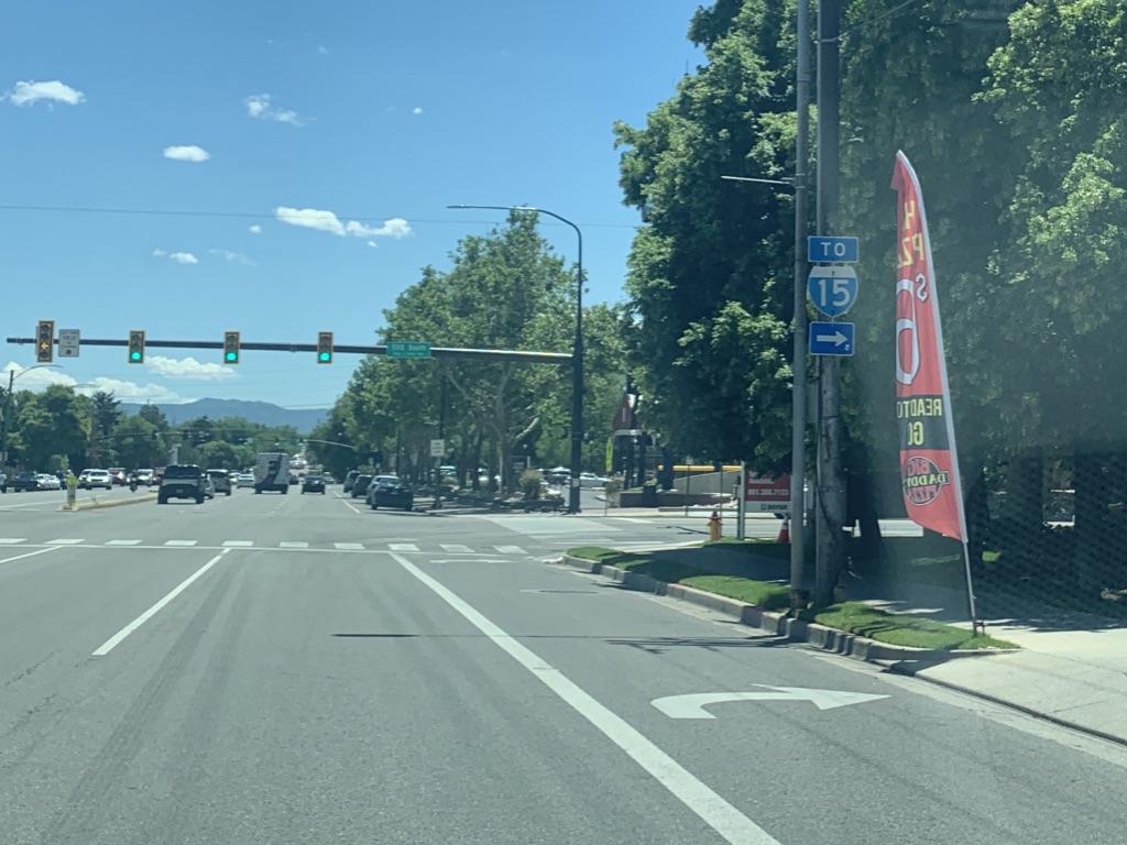
| Turn right on 12300 South to get to I-15... |
 |
| ... and also to stay on SR 71. This light is where SR 71 and 111 ended at each other for the middle third of the 20th century. |
 |
| 12300 South looking west after the turn. No reassurance marker. |
 |
| This road provides some nice views of the Oquirrh Mountains and the large copper mine in their foothills. |
 |
| The intersection with State Street is a Michigan Left, or ThrU Turn. This is where the eastbound U-turn occurs; as a result, we'll briefly find ourselves concurrent with northbound US 89. |
 |
| Turn right at the light ahead for US 89 northbound on State Street. Also turn right to make a u-turn to get to Minuteman Drive. |
 |
| Shortly after that intersection, we'll hit I-15. Seems like this JCT sign should have waited till after State, but whatever |
 |
| Not sure I've ever seen "trucks" in a yield sign like this. Appears to be because trucks have to swing wide when making this right turn and thus can't stay in the added lane. |
 |
| This is State Street. For the short distance between this light and the I-15 bridge in the background, we will be concurrent with US 89, though that designation is not signed. There used to be direct ramps from I-15 to State Street here, but they were removed in the early 2000s. |
 |
| Stay left for I-15 south to Provo, right for I-15 north to SLC. |
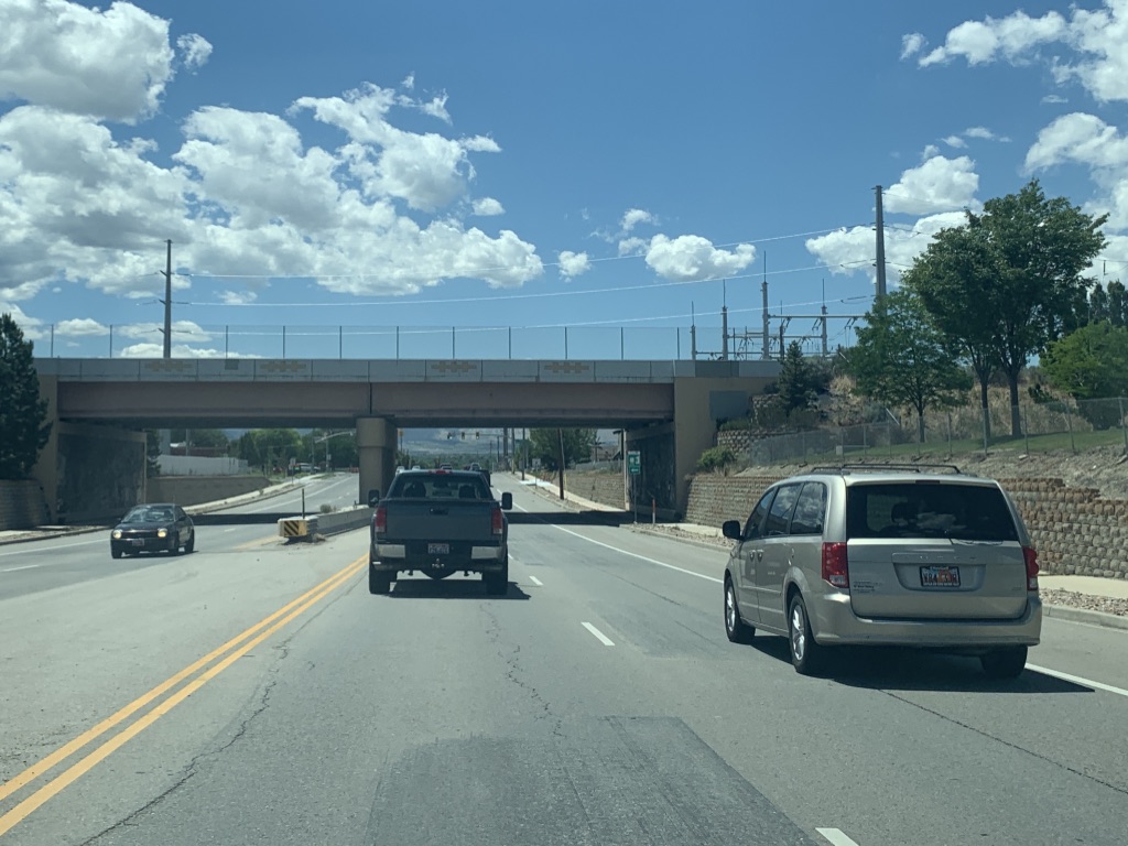
 |
| After crossing I-15 and leaving US 89, we'll pass under the railroad |
 |
| Gotta include both the numbers and names! |
 |
| 12300 South will now curve southward into 12600 South. |
 |
| Turn right to access the Jordan River Parkway, a multi-use trail that runs along the Jordan River through the length of Salt Lake County. |
 |
| SR 71 crosses the Jordan River and enters Riverton. |
 |
| We'll finish up the bend into 12600 South, a section line road through the west valley. |
 |
| Turn left for a city park. |
 |
| With zero advance signage, we'll come upon an intersection with Redwood Road which carries SR 68. |
 |
| Reassurance after that junction as we move onto the early 2000s extension of 71. |
 |
| A pedestrian bridge appears just before the light at 2700 West, probably due to the nearby Riverton High and Southland Elementary Schools. |
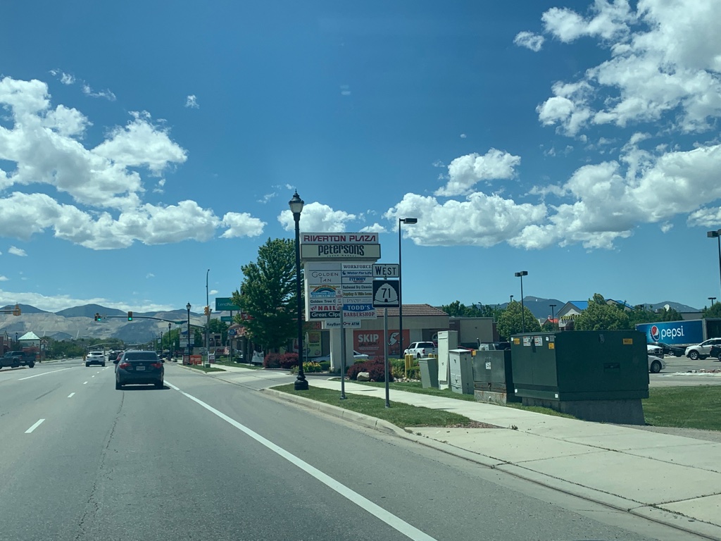
 |
| Another mile or so west, and we'll reach Bangerter Highway (SR 154). The 71 shield is inappropriate here as we're already on 71... and it's about to end. |
 |
| SR 71 reaches its south end here. At the time, this was an at-grade intersection; as of summer 2021 major construction is underway to upgrade this to an interchange. |
SR 111
All photos northbound, either from June 2018 (south of 4100 South) or June 2020 (north of 3500 South).
 |
| SR 111 will begin at the New Bingham Highway, which carries SR 209. |
 |
| Reassurance shield as we begin our journey north along the Bacchus Highway |
 |
One of very few horizontal traffic signals in the state occurs here at 8200 South, due to a low pedestrian bridge immediately behind the camera.
|
 |
| There is at one street sign for "U-111" - proving that although this method of referring to Utah state highways is very dated, it lives on. |
 |
| This railroad bridge dates back to the late 1940s. Unfortunately, it isn't used anymore and plans call for it to be removed when this segment of 111 is eventually widened. |
 |
| The light at 6200 South features this entire traffic signal assembly, complete with sign... but no lights. |
 |
| Another old and now-unused railroad bridge, but this one only dates back to the 1960s. |
 |
| We'll come to a junction with SR 173. |
 |
| Turn right on 5400 South for the west beginning of that route. Stay straight for 111. |
 |
| The next couple miles of SR 111 are some of the most interesting of any valley state route in an urban county. In a mile, all trucks must stop for a brake check. |
 |
| We'll even get a grade separation. This bridge was built for a Northrop Grumman facility, which has portions on both sides of the highway. |
 |
| All trucks exit here before we begin a steep drop. |
 |
| Steep enough, in fact, for a runaway truck ramp! |
 |
| The descent into Magna does have a great view of the northwestern Salt Lake Valley and Great Salt Lake wetlands behind. |
Skipping ahead to 3500 South...
 |
| SR 111 reassurance shield after passing 3500 South, which is SR 171 and old US 50. |
 |
| US 50 (and 40) turned left here onto Magna Main Street when they came through here back in the day. Also note the "when flashing do not enter" sign in the background... not sure what's up with that, but nearby 9180 West has a similar beacon with a "When Flashing SR 201 Closed" sign. Perhaps something to do with the smelter a few miles to the west? |
 |
| 111 ends here at the aforementioned SR 201. It's a split intersection, so this light is signed as "S.R.-201 East Bd." Presumably that means eastbound... but I've never seen that spelled out that way before. The END 111 sign is visible in the background, where the northbound road defaults onto westbound 201. |


No comments:
Post a Comment