For this post, we'll continue moving south through Utah and come to one of the longest - but also least traveled - corridors in the state: SR 21 and SR 153. They are effectively the same route, as they end within two blocks of each other in Beaver. We'll also discuss SR 159 and some of the historic spur routes and old alignments in this area.
 |
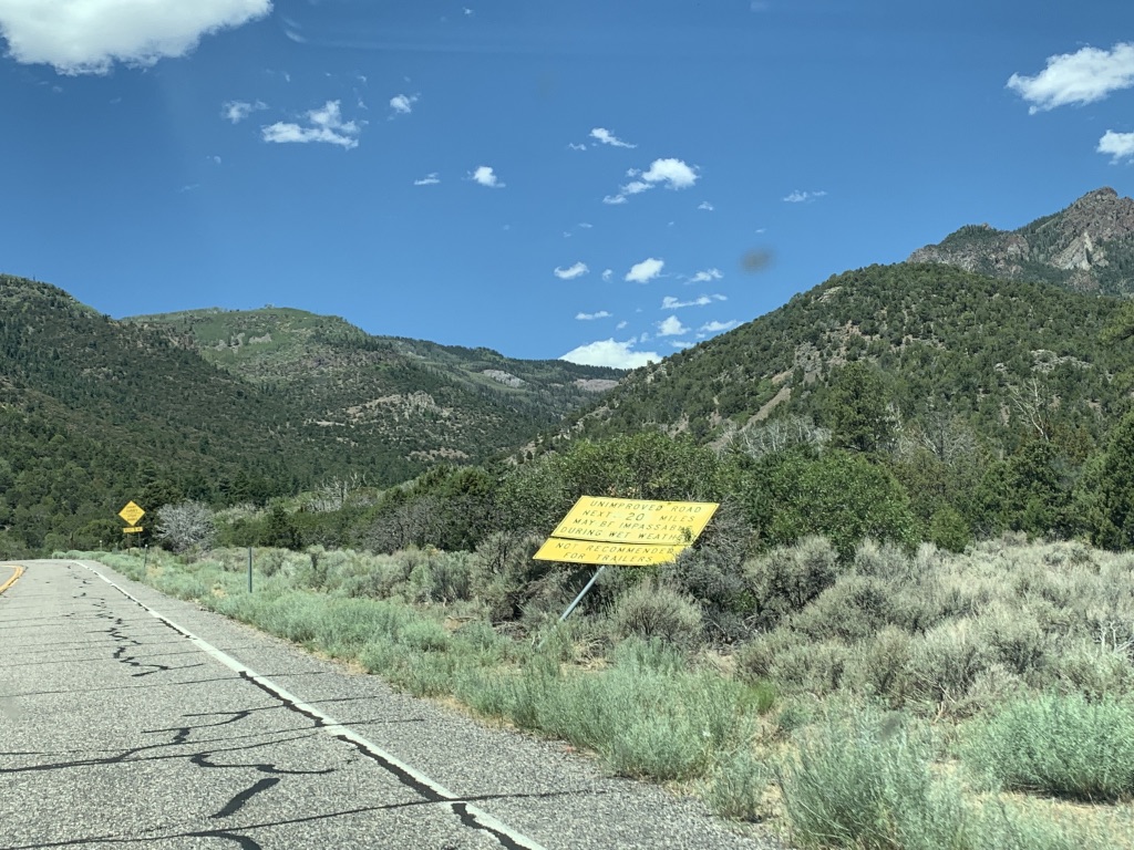
| A typical scene from SR 21 in western Utah, between Minersville and Milford. |
SR 21 is one of only five paved roads to fully traverse the Utah west desert, and by far the one with the lowest traffic counts (the others, in order of traffic count, are I-80, SR 56, US 6/50, and SR 30). The least-traveled section, between the Nevada state line and SR 159 at Garrison, sees an average of just 160 cars per day.
There is a bit more traffic at the east end thanks to the presence of actual population, most notably in the cities of Beaver and Milford. Those have always been Beaver County's two main cities, founded on the main wagon road and railroad respectively. It should come as no surprise, then, that the road from Beaver to Milford via Minersville was one of the first roads added to the state system all the way back in 1910. The highway left Beaver on Center Street, entered Milford on Main Street, and probably passed directly through Greenville, Adamsville, and Minersville (more on those below).
In 1916, the state highway was extended further, leaving Milford on Center Street and running west to a silver mining district in the San Francisco Mountains. The extended route served the town of Frisco before reaching its new terminus at Newhouse. Interestingly, by the mid-1910s most mining activity in the area had slowed down or stopped, though the Cactus Mine at Newhouse continued to turn a small profit through the 1910s.
The state highway system was trimmed down to around 20 legislatively defined routes, plus any federal aid projects, in 1919. The Beaver-Milford-Newhouse road was not among these defined routes, but because it had been improved with federal aid in 1917 and 1918, it remained on the state system.
In 1920, the road from Beaver east on 200 North and up Beaver Canyon to Puffer Lake was also added to the state system. It was shown, along with the Beaver-Milford-Newhouse road, on this early map from the Utah State Road Commission:
 |
| USRC, 1923. |
That shows that by 1923, the state had assigned numbers to the most important highways, and the north-south road through Beaver was by then SR 1 (it would later become US 91). But the Beaver-Milford-Newhouse road was not important enough to be numbered yet. The map actually showed the road to Newhouse continuing northwest all the way to the Nevada line. However, the map did not distinguish between unnumbered state highways and non-state highways, and this extension did not become a state highway until 1927.
This was also the year that all remaining unnumbered state highways were numbered - both the roads to Nevada and to Puffer Lake were designated SR 21:
21. From Beaver westerly via Milford, Newhouse and Garrison to the Nevada State line; also from Beaver easterly to Puffer's lake.
That would have resulted in a two-block implied overlap with US 91 through Beaver, along Main Street between Center and 200 North. It's unclear whether this was ever signed, though, and this question is probably unanswerable given the lack of maps with that level of detail.
The 1928 official Utah state map did not include state route numbers, but it did show the existence of a state highway from Nevada all the way to Puffer Lake:
 |
| USRC, 1928. |
Note also how the route is shown running through Greenville and Adamsville. Today, 21 passes Greenville to the north and Adamsville to the south...but it looks like it ran through both at first. It appears that in 1931, SR 21 was moved to a bypass of Greenville. To keep the town on the state highway system, the old alignment became a new state highway:
(127) From junction with route 21 west of Beaver, southerly to Greenville and westerly to junction with route 21.
When originally created, this route was numbered 127. However, when the original SR 121 was deleted two years later, all the 1931 routes between 122 and 129 inclusive were shifted down one. So 127 was renumbered to SR 126. It appeared on the 1940 US Census enumeration district map:
 |
| US Census, 1940. |
Two years later, a similar story happened a bit further west in Minersville. Today's SR 21 does not directly pass through Minersville...but it probably did at first. In 1933, a new SR 130 was created as a loop off SR 21 through Minersville. Here it is on the same census map:
 |
| US Census, 1940. |
That strongly suggests to me that before 1933, SR 21 ran through Minersville itself along 100 South and Center Street. SR 130 has an interesting history of its own after this point, but the rest of it will be covered in a future post.
1933 was also the creation year for another loop off 21, this one in the Milford valley. However, unlike 126 and 130, it was never an old alignment of 21 as far as I can tell. It was designated SR 129:
From junction with route 21 east of railroad crossing at Milford, southerly along section line four and one-half miles to southeast corner of section 31, township 28 south, range 10 west; thence easterly along township line two miles to junction with route 21.
This essentially ran due south from Milford to Cates Road (4500 South), where it turned east to return to 21:
 |
| US Census, 1940. |
In 1941, the east end of SR 21 was extended over the summit of the Tushar Mountains to the town of Junction, entering on Center Street and ending at its junction with Main Street (US 89/SR 11). This was essentially the maximum extent of the SR 21 system: a route from Nevada to Junction, with loops south of Milford and through Minersville and Greenville, with a two-block overlap on US 91 in Beaver.
 |
| State Farm/Rand McNally (Nevada-Utah), 1940. |
Utah has always hated overlaps, and apparently even a two-block 91/21 overlap in Beaver was too much for them. So in 1945, the Beaver-Junction road was split off into a new SR 153.
 |
| Shell/Gousha (Utah), 1950. |
The state legislature deleted a substantial portion of Utah's minor route mileage in 1953. SR 126 was among these routes - that year, the entire east-west portion was removed, and 126 became simply a spur from 21 south into Greenville. The same thing happened with the east-west portion of SR 130.
A similar but even larger-scale decommissioning happened in 1969. By then SR 130 had been repurposed into a north-south route to Cedar City, but the entirety of SR 126 and 129 were deleted from the state system. Interestingly, on westbound Thermo Rd (west of Minersville) there is still a "TO S.R.-129" sign that looks like a UDOT install - but a right turn there will put you on a road called "Hwy 129". That is the name Beaver County uses for the road south from Milford (street view link) ... however, the entire south half of what is currently labeled "Hwy 129" was never actually SR 129. (And of course, there is now a newer iteration of SR 129 in Utah County.)
In addition to these decommissionings, several new alignments were built for the routes that survived. SR 21 was moved to a bypass of Adamsville in 1960, but the old road probably still held some importance as both alignments continued to be displayed on maps for several decades after. The following USGS map was made in 1981, for example:
 |
| USGS (Beaver), 1981. |
Eight years later, the portion of 21 through Minersville Canyon (between Minersville Reservoir and Minersville) was straightened out:
 |
| USHD [Utah State Highway Department], 1968. |
A few changes were made on the western side of SR 21 as well. There may have been a handful of minor realignments at various times, but the only one notable enough for discussion here is the one at Pruess Lake (yes, there is an actual lake out here in the desert). Originally, SR 21 crossed Lake Creek immediately north of the lake, but sometime around the late 1970s, it was moved to a straighter alignment that crossed the creek much further north:
 |
| USGS (Garrison), 1951. |
 |
| USGS (Garrison), 1987. |
This was also right around the same time as the road from US 6/50 to Garrison was added to the state highway system. This road mostly serves as a paved shortcut connecting Garrison and US 6/50, saving 11 miles over the long route via Baker, Nevada and SR 487. Apparently Millard County got sick of maintaining it and requested to turn it over to UDOT. This was approved in 1978, and the road became SR 159.
SR 153 also received a few realignments that were a bit more substantial than the ones on 21. Originally, 153 followed a rather different routing in the upper portions of Beaver Canyon, running from the modern location of the Jimmy Reed trailhead directly east up Three Creeks Canyon to the Three Creeks confluence, then up Lake Stream to Puffer Lake along a road marked as Forest Road 135 on modern maps.
If you look at that route on a historic map, you'll notice some of it is not drivable today due to the existence of Three Lakes Reservoir. That is likely why it was realigned to approach Three Creeks from the north in 1974, along what is now marked FR 147:
 |
| USDH, 1973. |
But another realignment would be made within 15 years, this time between Puffer Lake and the Three Creeks Trailhead. This was done in order to serve the Mount Holly and Elk Meadows ski areas, which have since been combined and after a series of ownership changes are now known as Eagle Point. 153 was moved to the new highway in 1986:
 |
| UDOT, 1986. |
SR 153 remains in this configuration today. However, one final change was made to SR 21 in 2007, and that was to build a bridge over the Union Pacific Railroad at Milford. The original railroad crossing was at about 500 South (at the "PO" label on the map below) but that location was not usable for a grade separation. As a result, the new bridge was built a bit further southwest, and about 3/4 mile of new roadway was built:
 |
| USGS (Milford), 2014. |
Route Photos
SR 21
We'll begin heading east from the Nevada border to Garrison - photos taken June 2019:
 |
| A cattle guard and sign mark the state boundary, where Nevada SR 487 becomes Utah SR 21. |
 |
| The state line is also the boundary between the Pacific and Mountain time zones. It's good to have a sign, but this is technically wrong for about a third of the year when DST is not in effect. Perhaps this sign would be better placed along the Arizona border where DST is not observed. |
 |
| SR 21 is also United States Bicycle Route 79. |
 |
| The first actual 21 reassurance shield is an older one. |
 |
| Approaching the community of Garrison, the speed limit will drop to 40 mph in 800 feet. Utah seems to like the 800 foot distance warning for speed limit drops. |
 |
| Welcome to Garrison, which is so small it's not even a census-designated place. |
 |
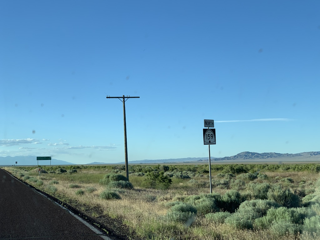
| Just north of the town we will junction SR 159, which is signed on one of the newer ugly beehive variants. |
 |
| Stay straight for SR 21 to Milford; turn left for SR 159 to Delta and US 6/50. The bottom two destinations really should be switched. |
 |
| SR 159 begins to the left. |
 |
SR 21 reassurance marker just past the junction. Milford is another 79 miles to the southeast.
|
Now, we'll begin in Beaver and head west to Milford. These were taken in August 2020:
 |
| First westbound reassurance marker in Beaver. |
 |
| SR 21 crosses I-15 without an interchange. |
 |
| Garrison is a really weird choice for a bottom-line control city. It is the last named settlement in Utah...but as we noticed above, it has barely anything. Ely would be a far better choice, but even Baker NV would be better. |
 |
| Minersville Lake and the Beaver County Fairgrounds are rather close...Great Basin National Park, not so much. |
 |
| Turn left for old SR 126 to Greenville. |
 |
| Turn right for old SR 21 to Adamsville. |
 |
| Reassurance shield after the Adamsville loop rejoins the modern 21 alignment. |
 |
| Turn right for unsigned SR 310 to Minersville Lake State Park. |
 |
| Minersville Lake is a reservoir on the Beaver River that provides irrigation water to much of the Milford valley. |
 |
| After passing the reservoir and a small canyon, turn left for old SR 130 (and old SR 21 before then) to the Beaver County Fairgrounds in Minersville. |
 |
| About a mile after that, we'll junction actual SR 130. |
 |
| Stay straight for Milford; turn left for Minersville and Cedar (City). Although many towns in the intermountain west drop "City" in common usage (such as Heber and Malad), Cedar City almost never loses its suffix. I believe this is the only signage lacking it. |
 |
| SR 130 begins to the left. |
 |
| Older SR 21 reassurance shield. We're also now concurrent with USBR 79, which runs north from Cedar City to the Nevada line at Baker. |
 |
| Onward to Milford, Delta, and Salt Lake City. Of the three cities here, only one is even on SR 21 - shows you how important the route through the west desert really is. |
 |
Turn left for Thermo Road, an important county road running through the southern Milford valley. Use that to get to Circle Four Farms and Dalton Farms Inc (and also James Farm Inc, who must have been mad they didn't make the UDOT sign).
|
 |
| SR 21 heads northwest across the barren plains of western Utah. |
 |
| Turn left for Cates Road, which was SR 129 before 1969. |
 |
| Another left here for Michael Yardley Farms. Apparently putting up a road sign for your farm is a thing down here. |
 |
| Based on precipitation, this is one of the last places you'd expect to see corn...but the Beaver River provides enough reliable irrigation water from the Tushar Mountains to make it work. |
 |
| Original SR 21 went dead ahead into Milford. Today, since a bridge over the train tracks has been built south of town, we'll curve to the left. |
 |
| The highway crosses old SR 129 here. |
 |
| Speed limit drops to 35 before the bridge...no doubt so that Milford police can make some money |
 |
| We'll enter Milford city limits just across the train tracks. |
 |
| Not sure I've ever seen this style of visitor info sign before. I like it. |
 |
| Although SR 21 is the through number, it is not the through road in Milford. In a half mile, turn left to continue out to Ely. |
 |
| Milford's Main Street. |
 |
In central Milford, USBR 79 will turn left as we junction SR 257.
|
 |
| Milford is definitely a railroad town and has a very different feel from most southern Utah small towns. |
 |
| USBR 79 turns left. |
 |
| Stay straight for Salt Lake, turn left for Ely and Great Basin National Park. |
 |
| SR 21 and USBR 79 turn left here in central Milford. SR 257 begins straight ahead. |
SR 153
All photos taken August 2020.
 |
| SR 153 begins in Junction and heads west on Main Street. |
 |
| Despite the COVID pandemic, the Butch Cassidy Rodeo was still happening, business as usual here...probably 500 people there...none with masks. |
 |
| After leaving the site of our next COVID outbreak, we'll get a mileag sign for Puffer Lake and Beaver. Clearly the top sign used to be brown. |
 |
| SR 153 is one of a handful of Utah state routes that close in winter. This is the eastern closure point. |
 |
| Entering the Fishlake National Forest. |
 |
| It's funny that this was the one sign knocked down, because the content on it is probably more important than all the other signs we've seen so far... |
 |
| Be warned, SR 153 ahead features sharp curves and steep grades. |
 |
| Signage is not great up here...but if you guess correctly by those "straight" arrows that you need to bear left here, you'll continue on 153 westbound. |
 |
| Highway legal vehicles only. I wonder why... |
 |
| ...turns out it's because the road isn't paved! This is one of only two remaining unpaved state highways in Utah, the other being SR 261. |
 |
| The highway features excellent views of the upper Sevier Valley to the east. |
 |
| 153 continues ascending the steep eastern side of the Tushar Mountains. |
 |
| One final look to the east, with the town of Circleville in the distance. |
 |
| After the steep initial climb, the road levels out a bit and climbs into the aspen forest. |
 |
| As we gain more elevation, the aspens begin to change to evergreens. |
 |
| We then open out into a small meadow and gain the tall orange poles commonly seen on roads that get a lot of snow. |
 |
| This is a bad sign. It says Beaver is to the left in 25 miles...but that is almost certainly not the best way to Beaver. You're far better off bending slightly right here to stay on SR 153...but that is not signed. |
 |
| Beaver is 29 miles away, according to this UDOT-spec sign that serves as some sort of reassurance that we've actually stayed on the state highway here. |
 |
| ATV crossing here...but really, this entire unpaved portion of SR 153 is spent dodging ATVs. |
 |
| A reassurance marker! This is the only westbound SR 153 shield on the unpaved segment. |
 |
| We get great views of the highest peaks of the Tushar Mountains, which are unique among southern Utah mountains in that they reach well above tree line. |
 |
| Turn for the Skyline National Recreation Trailhead. |
 |
| This sign used to be yellow. It is now blue. |
 |
| Turn right for Puffer Lake. Stay straight for Beaver as we return to pavement. |
 |
| This "summit" is only the highest point on the paved portion of 153 - the unpaved part gets a few hundred feet higher. |
 |
| Nice old reassurance shield with a scenic byway marker to go with it. |
 |
| 10% grades are not to be fooled around with. This is one of the steepest roads on the Utah state highway system. |
 |
We'll cross the Paiute ATV trail, which leads to the Beaver High Adventure Base
|
 |
| This is the Three Creeks Trailhead and the end of the 1986 realignment; we are about to hop on the 1974 realignment westbound. A left turn here would put one on the pre-1986 alignment eastbound. Although probably not strictly necessary, the complex history of different alignments is likely why Beaver is signed here. |
 |
| Good information, but this is a warning sign and should be yellow instead of regulatory white. |
 |
| They got it right two miles further down. |
 |
| Turn for the Mahogany Cove Campground. |
 |
| Next, we'll cross a pipe of some sort |
 |
| Another reassurance marker, this time with shield and direction switched. |
 |
| As the canyon levels out, the vegetation switches back to leafy deciduous trees. |
 |
| This is a UDOT sign pretending to be a forest service sign. Not sure I've seen that before. |
 |
| Now in central Beaver, we can turn left on Business Loop 15 for Cedar City or right for Salt Lake. |
 |
| BL-15 is also SR 160 and old US 91. SR 153 will end here without signage. |
SR 159
Photos taken June 2019.
 |
| Initial reassurance marker heading north from Garrison. |
 |
| 8 miles from here to "US-6 & 50" which might be the only time I've ever seen the & character on a mileage sign. |
 |
| This was a fascinating drive - largely due to groundwater from the Snake Range to the west, this valley is filled with actual grass instead of sagebrush. |
 |
| Another reassurance marker. |
 |
| A few miles later, we reach US 6/50. |
 |
| Turn left for Ely, right for Delta. Looks like that bird found a nice tasty mouse to munch on. |
 |
| Gas and hotel may be found in the Border Inn, a little under a mile west of here. |
 |
| SR 159 ends. |
 |
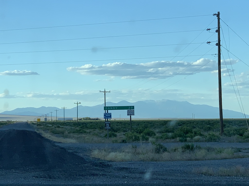
| Although it is not state maintained, the road itself continues north to Gandy and a handful of other very small communities. |


No comments:
Post a Comment